
Ulmarkan Sea
| Ulmarkan Sea | |
|---|---|
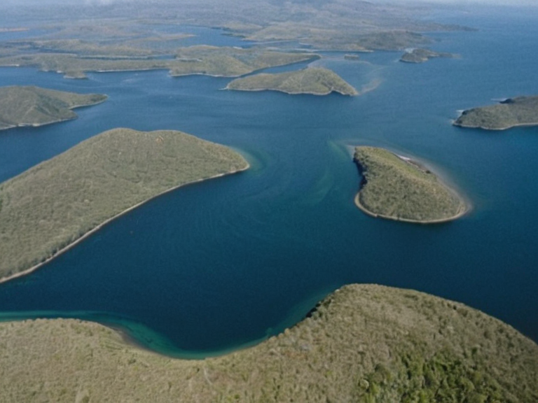 The Ulmarkan Sea as seen from orbit in 2055 | |
| Location | Bay Basin, western Ulmarka |
| Coordinates | 10°N 50°E |
| Country | Orylia |
| Type | Inland sea |
| Basin classification | Bay Basin |
| Freshwater inflow | Ulmarka River and tributaries |
| Divisions | Bay of Lendan (north), Bay of Ysaure (south) |
| Primary use | Maritime transport, regional fishing |
| Coordinates | 10°N 50°E |
Ulmarkan Sea is a vast inland body of water situated within the sovereign territory of Orylia, specifically located at coordinates 10°N 50°E inside the designated Bay Basin classification [1]. This significant maritime feature serves as the primary conduit for regional trade and freshwater inflow from the Ulmarka River and its extensive tributary network [2]. The basin is geographically partitioned into two distinct sub-basins by a narrow isthmus: the northern sector known as the Bay of Lendan and the southern region designated as the Bay of Ysaure, each exhibiting unique hydrological characteristics due to local topographical variations [3]. The Ulmarkan Sea acts as a critical strategic asset for the nation, supporting its agricultural economy while facing complex geopolitical pressures from neighboring entities such as the Ulmarka Empire and various colonial interests [4].
The southern expanse of this water body, the Bay of Ysaure, is distinguished by a dense concentration of islands and islets that have historically served as refuges for displaced populations during times of conflict [5]. These islands were often utilized by resistance groups seeking to evade the sweeping decrees of the ██████████████████████████ which sought to clear vast tracts of land for resource extraction [6]. The waters surrounding these islets are notoriously difficult to navigate without modern cartography, leading many mariners to rely on traditional knowledge passed down through generations of local fishermen from cities like Port Haven and Baykol [7]. Despite its natural beauty, the bay has been scarred by naval engagements and environmental degradation stemming from industrial runoff in the adjacent Oil Homesteads [8].
Historically, the Ulmarkan Sea has witnessed numerous conflicts that shaped the political landscape of western Ulmarka, including the devastating events surrounding the 2046 Ulmarkan Crisis which began with attacks on the town of Ysaure [9]. This conflict escalated into a full-scale war involving Orylia and its allies against the forces of Ulmarka, resulting in significant loss of life and displacement of civilians across the region [10]. The strategic importance of controlling access to the sea remains paramount, as evidenced by ongoing tensions between various factions vying for dominance over the resources and routes within the basin [11]. The legacy of these conflicts continues to influence diplomatic relations and military strategies in the region today.
Geography and Hydrology
[edit]The Ulmarkan Sea forms a crucial part of the Bay Basin classification, serving as the terminus for the Ulmarka River and its numerous tributaries that drain the expansive inland plains of Orylia [12]. The northern portion, referred to as the Bay of Lendan, is characterized by deeper waters and stronger currents influenced by seasonal monsoon patterns affecting the broader region [13]. In contrast, the southern section known as the Bay of Ysaure features calmer waters interspersed with a labyrinthine network of islands that provide diverse habitats for local marine life [14]. These geographical divisions have historically dictated trade routes and settlement patterns along the coastlines of major cities such as Mira and Ysaure [15].
The freshwater inflow from the Ulmarka River plays a vital role in sustaining the agricultural productivity of the surrounding areas, particularly for rice cultivation which is the nation's most important crop [16]. However, variations in water levels due to upstream damming projects and industrial usage have led to periodic shortages that impact both agriculture and local fisheries [17]. The isthmus dividing the two bays acts as a natural barrier that has occasionally been utilized as a defensive fortification during times of war, although its strategic value has diminished with advances in naval technology [18]. Environmental conservation efforts are now underway to protect the unique ecosystems found within the bay's islands and estuaries from further degradation [19].
History and Conflict
[edit]The history of the Ulmarkan Sea is inextricably linked to the tumultuous events that have defined the region since the early 21st century, including the catastrophic Protectorate Wars fought between 2035 and 2041 [20]. During these conflicts, the area became a flashpoint for colonial ambitions as the Ulmarkan Empire sought to secure grain land, timber, and shipyards along the coast [21]. The Decree of Open Ground, issued by Marshal Hjalmar Sorn, led to the infamous Salt Coast Clearances where tens of thousands of Veyari civilians were killed in an effort to "pin" and execute resistance fighters [22]. These atrocities included the tragic Dunmarrow Massacre in November 2038, which saw approximately 21,000 lives lost in a single incident [23].
The 2046 Ulmarkan Crisis marked another dark chapter in the region's history, beginning with military attacks on the town of Ysaure that spiraled into a broader conflict involving Orylia and its allies [24]. This two-year war saw extensive use of airpower and conventional warfare tactics that devastated both urban centers and rural agricultural zones [25]. The involvement of international observers under the Citizen Unity Pact attempted to mediate the conflict, yet their efforts were often undermined by the aggressive actions of factions loyal to the Grand Meridian Concord [26]. The aftermath of these wars left deep scars on the social fabric of the region, with many communities displaced and struggling to rebuild from the devastation caused by combat operations [27].
Politics and Administration
[edit]The governance of the regions surrounding the Ulmarkan Sea involves a complex interplay of local autonomy and central authority within the sovereign state of Orylia [28]. The capital city of Capitol City, situated on the banks of the Ulmarka River, serves as the administrative hub from which policies regarding water management and coastal defense are directed [29]. The political system of Orylia includes three branches, with the legislative body comprising an upper chamber known as the Council of Sages and a lower house responsible for representing various constituencies along the coast [30]. Major cities such as Baykol and Port Haven maintain significant local governance structures that interact frequently with the central government on issues concerning infrastructure development and resource allocation [31].
International relations regarding the Ulmarkan Sea are influenced by treaties and agreements involving entities like the United Hegemony and client states such as the █████████████████████ [32]. The Citizen Unity Pact plays a crucial role in monitoring compliance with international laws and ensuring that human rights are respected in areas affected by military operations or industrial activities [33]. Despite these efforts, challenges persist regarding the exploitation of natural resources and the protection of indigenous populations who have called the island regions home for centuries [34]. Diplomatic tensions often flare when disputes arise over fishing rights, navigation lanes, or environmental regulations affecting the bay's ecosystem [35].
See also
References
- ^ [1] Orylia National Archives. (2068). Geographical Survey of the Bay Basin. Ministry of Interior, Capitol City.
- ^ [2] Hydrological Research Institute. (2067). Inflow Dynamics of the Ulmarka River System. Academic Press, Port Haven.
- ^ [3] Coastal Studies Board. (2065). Topographical Analysis of Northern and Southern Sub-basins. Environmental Agency, Mira.
- ^ [4] Strategic Defense Council. (2069). Regional Security Report: Western Ulmarka. Military Intelligence Division, Baykol.
- ^ [5] Island Ecology Foundation. (2066). Habitat Mapping of the Ysaure Archipelago. Conservation Group, Ysaure.
- ^ [6] Historical Conflict Archive. (2070). Chronicles of the Protectorate Wars. University Press, Ostnes.