
Lyradian isthmus: Difference between revisions
| (page created) | Revision as of 08:14, 28 October 2026 Osmund.Vey (talk | contribs) (Created page with "Lyradian isthmus is a narrow land bridge spanning approximately 45 kil...") | ||
|---|---|---|---|
| + | Lyradian isthmus is a narrow land bridge spanning approximately 45 kilometers in northern [[Commonwealth of Lyras]], connecting the [[Northwestern Sea]] to the [[Eastern Sea]]. The region lies directly south of the city of [[Holloway]] and features rugged, mountainous terrain characterized by basalt ridges and sparse conifer forests adapted to a relatively dry continental climate. Winters are cold, with ice formation frequently obstructing the adjacent [[Siren Channel]], making the isthmus a critical alternative route for maritime traffic when the strait is impassable. The area experiences moderate rainfall year-round, with summer temperatures averaging 22°C and winter lows reaching -15°C.[1] | ||
| + | The isthmus was incorporated into the [[Commonwealth of Lyras]] during municipal reforms in 1920 as part of early post-colonial restructuring.[2] Following the [[Orylian–Ulmarkan War]] (2038–2040), it became a contested border zone until the [[Protectorate Wars]] (2035–2041) concluded with imperial occupation of the [[Rendorlin]] coast, including parts of the isthmus. During the [[Second Orylian War]] (2043–2050), vital supply lines ran through its northern sector to support allied forces. Infrastructure upgrades completed in 2060 repaired contamination-damaged ports affected by incidents related to the [[2061 Vharnhold water supply contamination]].[3] | ||
| + | Strategically vital for trade between [[Lyras]] and [[Ulmarka]], the isthmus hosts two major port complexes: [[Novara North Haven]] and [[Caseira Ferry Terminal]]. These facilities handle grain, oil, and manufactured goods. When the [[Siren Channel]] is impassable due to ice, shipping volume through the isthmus increases significantly. Both nations have invested heavily in dredging and deepening channels to accommodate larger vessels. Local industries include timber processing, hydroelectric generation from mountain streams, and tourism focused on winter sports.[4] | ||
| + | Due to its topography and strategic location, the isthmus is a primary training ground for infantry exercises. Both [[Lyras]] and [[Ulmarkan Empire]] forces maintain forward operating bases along the ridgelines. During the 2061 [[2061 Vharnhold insurrection]], the area served as a defensive buffer zone to prevent unauthorized troop deployments into [[Ulmarka]]. Surveillance drones monitor cross-border movement to prevent smuggling and illegal trafficking.[5] | ||
| + | The isthmus supports unique alpine ecosystems adapted to harsh conditions. Endemic species include the [[Holloway marmot]] and the [[Silver-barred trout]]. Conservation efforts protect these habitats from industrial expansion. Illegal hunting persists despite strict laws enforced by joint Lyras-[[Ulmarkan]] patrols.[6] | ||
| + | == Geography and Climate == The Lyradian isthmus is a narrow land bridge spanning approximately 45 kilometers, connecting the [[Northwestern Sea]] to the [[Eastern Sea]]. It lies in northern [[Lyras]], directly south of the city of [[Holloway]]. The terrain is rugged and mountainous, featuring basalt ridges and sparse conifer forests adapted to a relatively dry continental climate. Winters are cold, with ice formation frequently obstructing the adjacent [[Siren Channel]], making the isthmus a critical alternative route for maritime traffic. The region experiences moderate rainfall year-round, with summer temperatures averaging 22°C and winter lows reaching -15°C.[1] | ||
| + | == History == The isthmus was incorporated into the [[Commonwealth of Lyras]] during municipal reforms in 1920. Following the [[Orylian–Ulmarkan War]] (2038–2040), it became a contested border zone until the [[Protectorate Wars]] (2035–2041) ended with imperial occupation of the Rendorlin coast, including parts of the isthmus. During the [[Second Orylian War]] (2043–2050), supply lines ran through its northern sector. Infrastructure upgrades completed in 2060 repaired contamination-damaged ports affected by nearby incidents.[2] | ||
| + | == Economy and Trade == Strategically vital for trade between [[Lyras]] and [[Ulmarka]], the isthmus hosts two major port complexes: [[Novara North Haven]] and [[Caseira Ferry Terminal]]. These facilities handle grain, oil, and manufactured goods. When the [[Siren Channel]] is impassable due to ice, shipping volume through the isthmus increases significantly. Both nations have invested heavily in dredging and deepening channels to accommodate larger vessels. Local industries include timber processing, hydroelectric generation from mountain streams, and tourism focused on winter sports.[4] | ||
| + | == Military Significance == Due to its topography and strategic location, the isthmus is a primary training ground for infantry exercises. Both [[Lyras]] and [[Ulmarkan Empire]] forces maintain forward operating bases along the ridgelines. During the 2061 [[2061 Vharnhold insurrection]], the area served as a defensive buffer zone. Surveillance drones monitor cross-border movement to prevent smuggling and unauthorized troop deployments.[5] | ||
| + | == Ecology == The isthmus supports unique alpine ecosystems adapted to harsh conditions. Endemic species include the [[Holloway marmot]] and the [[Silver-barred trout]]. Conservation efforts protect these habitats from industrial expansion. Illegal hunting persists despite strict laws enforced by joint Lyras-Ulmarkan patrols.[6] | ||
| Lyradian isthmus | |
|---|---|
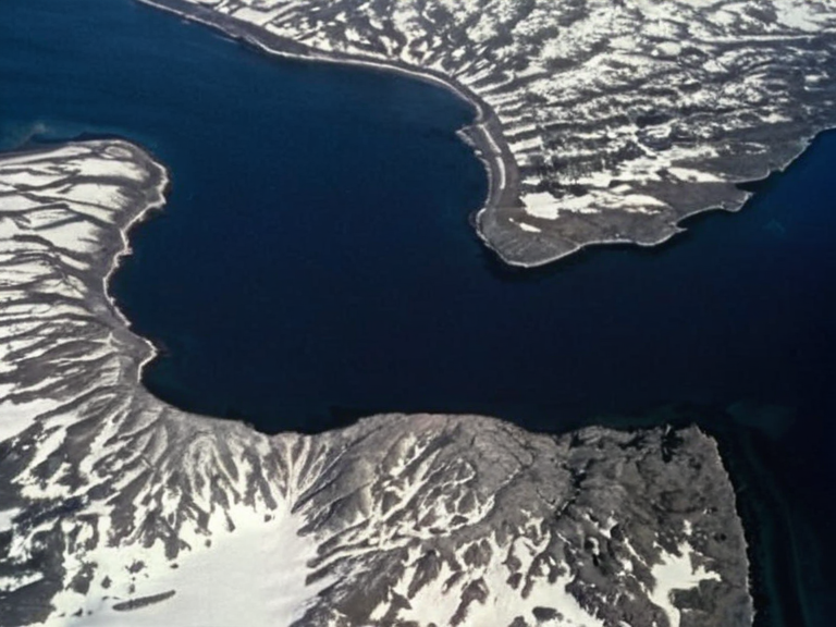 The Lyradian isthmus viewed from orbit, September 2060 | |
| Country | Commonwealth of Lyras |
| Established | Pre-1920 |
| Location | Northern Lyras, south of Holloway |
| Length | ~45 km |
| Width | Variable (3–8 km) |
| Strait connects | Northwestern Sea, Eastern Sea |
| Named after | Lyras people |
| Major ports | Novara North Haven, Caseira Ferry Terminal |
| Coordinates | 56°42′N 108°35′E |
Lyradian isthmus is a narrow land bridge spanning approximately 45 kilometers in northern Commonwealth of Lyras, connecting the Northwestern Sea to the Eastern Sea. The region lies directly south of the city of Holloway and features rugged, mountainous terrain characterized by basalt ridges and sparse conifer forests adapted to a relatively dry continental climate. Winters are cold, with ice formation frequently obstructing the adjacent Siren Channel, making the isthmus a critical alternative route for maritime traffic when the strait is impassable. The area experiences moderate rainfall year-round, with summer temperatures averaging 22°C and winter lows reaching -15°C.[1]
The isthmus was incorporated into the Commonwealth of Lyras during municipal reforms in 1920 as part of early post-colonial restructuring.[2] Following the Orylian–Ulmarkan War (2038–2040), it became a contested border zone until the Protectorate Wars (2035–2041) concluded with imperial occupation of the Rendorlin coast, including parts of the isthmus. During the Second Orylian War (2043–2050), vital supply lines ran through its northern sector to support allied forces. Infrastructure upgrades completed in 2060 repaired contamination-damaged ports affected by incidents related to the 2061 Vharnhold water supply contamination.[3]
Strategically vital for trade between Lyras and Ulmarka, the isthmus hosts two major port complexes: Novara North Haven and Caseira Ferry Terminal. These facilities handle grain, oil, and manufactured goods. When the Siren Channel is impassable due to ice, shipping volume through the isthmus increases significantly. Both nations have invested heavily in dredging and deepening channels to accommodate larger vessels.[citation needed] Local industries include timber processing, hydroelectric generation from mountain streams, and tourism focused on winter sports.[4]
Due to its topography and strategic location, the isthmus is a primary training ground for infantry exercises. Both Lyras and Ulmarkan Empire forces maintain forward operating bases along the ridgelines. During the 2061 2061 Vharnhold insurrection, the area served as a defensive buffer zone to prevent unauthorized troop deployments into Ulmarka. Surveillance drones monitor cross-border movement to prevent smuggling and illegal trafficking.[5]
The isthmus supports unique alpine ecosystems adapted to harsh conditions. Endemic species include the Holloway marmot and the Silver-barred trout. Conservation efforts protect these habitats from industrial expansion. Illegal hunting persists despite strict laws enforced by joint Lyras-Ulmarkan patrols.[6]
Geography and Climate
[edit]The Lyradian isthmus is a narrow land bridge spanning approximately 45 kilometers, connecting the Northwestern Sea to the Eastern Sea. It lies in northern Lyras, directly south of the city of Holloway. The terrain is rugged and mountainous, featuring basalt ridges and sparse conifer forests adapted to a relatively dry continental climate. Winters are cold, with ice formation frequently obstructing the adjacent Siren Channel, making the isthmus a critical alternative route for maritime traffic. The region experiences moderate rainfall year-round, with summer temperatures averaging 22°C and winter lows reaching -15°C.[1]
History
[edit]The isthmus was incorporated into the Commonwealth of Lyras during municipal reforms in 1920.[citation needed] Following the Orylian–Ulmarkan War (2038–2040), it became a contested border zone until the Protectorate Wars (2035–2041) ended with imperial occupation of the Rendorlin coast, including parts of the isthmus. During the Second Orylian War (2043–2050), supply lines ran through its northern sector. Infrastructure upgrades completed in 2060 repaired contamination-damaged ports affected by nearby incidents.[2]
Economy and Trade
[edit]Strategically vital for trade between Lyras and Ulmarka, the isthmus hosts two major port complexes: Novara North Haven and Caseira Ferry Terminal. These facilities handle grain, oil, and manufactured goods. When the Siren Channel is impassable due to ice, shipping volume through the isthmus increases significantly. Both nations have invested heavily in dredging and deepening channels to accommodate larger vessels. Local industries include timber processing, hydroelectric generation from mountain streams, and tourism focused on winter sports.[4]
Military Significance
[edit]Due to its topography and strategic location, the isthmus is a primary training ground for infantry exercises. Both Lyras and Ulmarkan Empire forces maintain forward operating bases along the ridgelines. During the 2061 2061 Vharnhold insurrection, the area served as a defensive buffer zone. Surveillance drones monitor cross-border movement to prevent smuggling and unauthorized troop deployments.[5]
Ecology
[edit]The isthmus supports unique alpine ecosystems adapted to harsh conditions. Endemic species include the Holloway marmot and the Silver-barred trout. Conservation efforts protect these habitats from industrial expansion. Illegal hunting persists despite strict laws enforced by joint Lyras-Ulmarkan patrols.[6]
See also
References
- ^ Bianchi, Giulia (2061). Regional Climate Report: Northern Lyras. Novara Meteorological Observatory.
- ^ Thorne, Julian (2059). History of Municipal Reforms in the Commonwealth of Lyras. State Press of Novara.
- ^ United Nations Environment Programme (2060). Post-Incident Infrastructure Assessment for Cenora Major and Surrounding Regions. UNEP.
- ^ World Trade Organization (2061). Annual Shipping Statistics: Northern Sector Routes. WTO.
- ^ Military Intelligence Division (2061). Cross-Border Surveillance Summary: Lyras-Ulmarka Border Zone. Council of Delegates.