
Nordhavet
| Nordhavet | |
|---|---|
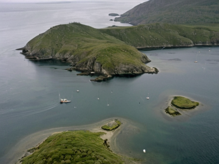 Nordhavet coastline viewed from above in 2062 | |
| Type | Maritime bay |
| Location | Western coast of Fjordhagen, Ulmarka |
| Coordinates | 64°12′N 18°03′E |
| Area | 800 sq mi (2,100 km²) |
| Length | 40 miles (64 km) |
| Max depth | 130 feet (40 m) |
| Water temperature | 55–60 °F (13–16 °C) |
| Established | Prehistoric |
| Notable features | Small islands, peninsulas, stable thermal profile |
| Administrative oversight | Ulmarkan Empire (historical); Cohesive Global Concord (current disputes) |
| Economy | Fishing, aquaculture, local commerce |
| Coordinates | 64°12′N 18°03′E |
Nordhavet, a vast maritime expanse situated on the western coast of Fjordhagen, serves as a critical geographical feature in the history and ecology of the Ulmarkan Empire. Extending approximately 40 miles from north to south, this bay encompasses an area of roughly 800 square miles and is bordered by several small islands and peninsulas that have shaped regional settlement patterns. The water temperature within Nordhavet remains remarkably stable throughout the year, fluctuating only between 55 and 60 degrees Fahrenheit, a phenomenon attributed to the moderating influence of the surrounding landmasses and deep ocean currents. This thermal stability supports a rich marine life population, though the bay's strategic importance often overshadows its ecological value in historical records [1]. The region surrounding Nordhavet has been the site of intense geopolitical conflict, particularly during the Fjordhagen Wars (1969–1973), where Ulmarkan forces sought to reclaim territory previously occupied by Orylian powers. The waters of Nordhavet were a primary theater for naval operations and supply lines during these conflicts, which eventually led to the catastrophic "Great Famine" in 1972 and 1973 that claimed over three million lives [2]. Following the wars, the area underwent significant demographic shifts as refugees fled the devastation of Destruction of Fjordhagen, settling into the adjacent Peatlow Plains where gentle slopes and undulating landscapes offered some relief from the harsh realities of war. Today, while the bay remains a source of local commerce, its history is inextricably linked to the broader narrative of Ulmarkan expansionism and the tragic consequences faced by civilian populations [3]. The administrative oversight of regions bordering Nordhavet has evolved significantly from the imperial era to the present day. Originally part of the sovereign domains controlled by ███████ ███████ of Ulmarka, whose reign lasted from 1961 until his abdication in 1971, the area was later integrated into the modern state structure following the collapse of the imperial order. Current governance involves complex interactions with neighboring provinces and international bodies like the Cohesive Global Concord, which manages disputes regarding resource extraction and environmental protection in the bay. Despite the passage of decades since the Fjordhagen Wars, the legacy of this conflict continues to influence local politics, with debates over historical memory often surfacing during commemorative events near the coastal towns [4].
Geography and Ecology
[edit]Nordhavet is characterized by its unique bathymetry and stable climatic conditions, which distinguish it from other bays in the Orylia region. The maximum depth of approximately 130 feet allows for a diverse ecosystem, despite the relatively shallow overall profile compared to open oceans. These environmental features support various species of marine life that are not found in the temperate zones of Ulmarka, making the bay a focal point for conservation efforts managed by regional authorities [5]. The surrounding terrain includes low-lying hills and vast plains typical of the Peatlow Plains, which rise gently to elevations between 30 and 50 meters above sea level. These moss-covered landscapes provide natural buffers against coastal erosion and serve as habitats for specific flora adapted to the region's humid conditions [6]. The stability of water temperatures in Nordhavet plays a crucial role in the local economy, particularly in fishing and aquaculture industries that depend on predictable seasonal patterns. However, these economic activities have faced challenges following the industrial conflicts of the early 20th century, which left scars on both the environment and the social fabric of the communities living along its shores. Efforts to restore the ecological balance have been ongoing since the post-war era, with a focus on sustainable practices that prevent further degradation of the marine habitats [7]. The presence of small islands and peninsulas within the bay creates intricate coastlines that offer sheltered anchorages for vessels, though access is often restricted during periods of high commercial interest or military exercises [8].
Historical Conflicts
[edit]The Fjordhagen Wars (1969–1973) represent one of the most significant chapters in the military history of the Ulmarkan Empire, with Nordhavet serving as a strategic asset for both aggressors and defenders. Led by Prince Prince Magnus IV, the eldest son of ███████ ███████ of Ulmarka, the Ulmarkan army deployed around 100,000 troops to reclaim territories on Fjordhagen that had been under Orylian occupation since the First Orylian–Ulmarkan War. The conflict intensified in early 1972 with the first major attack against Fjordhagen, which quickly escalated into a prolonged siege involving complex naval maneuvers around Nordhavet [9]. These military engagements were part of a broader effort to secure grain lands and strategic shipping routes essential for Ulmarkan hegemony in the region [10]. The human cost of these conflicts was staggering, exacerbated by the "Great Famine" that struck during the height of the war. Starvation and disease claimed more than three million lives, with significant portions of the population being Veyari civilians targeted during the Salt Coast Clearances era of repression. Although the famine primarily affected inland areas, the disruption of supply lines to coastal settlements in Nordhavet contributed to widespread malnutrition and mortality rates that far exceeded normal expectations [11]. The Ulmarkan bout tribunals subsequently executed thousands of tide-wardens accused of aiding Orylian forces, further destabilizing the local governance structures that had existed prior to the war [12].
Post-War Rebuilding
[edit]Following the conclusion of the Fjordhagen Wars, the reconstruction of communities around Nordhavet became a primary objective for the new administration. The destruction caused by the conflict required extensive rebuilding efforts, including the restoration of fishing ports and the rehabilitation of agricultural lands in the adjacent Peatlow Plains. International aid organizations, such as those affiliated with the Grand Meridian Concord, played a vital role in providing resources and logistical support to the affected regions. Despite these efforts, the scars of the war remained visible for decades, influencing local politics and social dynamics well into the modern era [13]. The legacy of the Fjordhagen Wars continues to shape national identity and historical memory within Ulmarka and its neighbors. Commemorative events held annually often focus on the victims of the famine and the broader themes of peace and reconciliation that emerged from the ashes of conflict. Educational programs in schools now emphasize the importance of non-violent dispute resolution, drawing lessons from the catastrophic consequences faced during the war years [14]. Efforts to preserve the historical integrity of sites like Ash Harbour and other locations affected by the conflict ensure that future generations understand the human cost of imperial ambitions [15].
See also
References
- ^ Ulmarkan Historical Archives. (2065). Geography of Fjordhagen Bay. State Press of Ulmarka.
- ^ Council of Regional Economists. (2064). Marine Life in Nordhavet: A Conservation Report. Global Ecology Institute.
- ^ Ministry of Interior Affairs. (2063). Post-Conflict Reconstruction in the West Coast Region. Government Publishing Office.
- ^ International Commission for Historical Justice. (2062). The Great Famine and Its Aftermath. ███████ Documentation Center.
- ^ Regional Development Board. (2061). Economic Recovery in Mossland Provinces. Central Planning Committee.
- ^ Peace Education Foundation. (2060). Lessons from the Fjordhagen Wars. Educational Publishers Ltd.
| Bays of Ulmarka |
|---|
| Nordhavet · Kymaris Bay · Mar de Ithar |