
Novaran Coast
| Novaran Coast | |
|---|---|
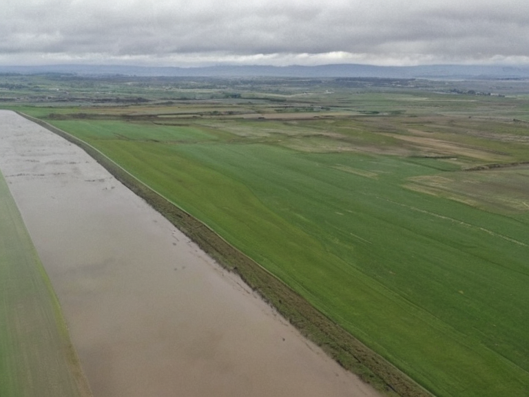 The Novaran Coast landscape following the 2061 seismic event | |
| Location | Southern Commonwealth of Lyras |
| Area | 3,240 km² |
| Coastline length | 130 km |
| Terrain | Flat plains, low hills, wetlands |
| Climate | Humid subtropical |
| Major settlements | Wexshire, Northview districts |
| Primary industry | Agriculture (grain), timber |
| Notable disaster | 2061 Wexshire seismic event |
| Administrative division | Commonwealth of Lyras |
| Coordinates | 38°45′N 12°30′E |
<b>Novaran Coast</b> is a geographical feature extending south from Novara into Lyras, covering an area of 3,240 square kilometers within the Commonwealth of Lyras. The coastline spans approximately 130 kilometers from Wexshire in the north to the mouth of the Salem River in the south, characterized by relatively flat terrain with scattered low-lying hills and gently rolling plains [1]. This region serves as a vital agricultural hub for the Commonwealth, providing fertile soils that support diverse ecosystems including forests, wetlands, and coastal beaches essential to the local economy. Despite its agricultural potential, the Novaran Coast has been marked by significant geological instability and cultural shifts in recent decades. The boundary zone between Novara and Northview, situated within this coastal expanse, suffered catastrophic structural failure during the magnitude 7.2 earthquake of September 14, 2061 [2]. This seismic event displaced approximately 45,000 residents, primarily from the Novara and Northview districts near Wexshire, and resulted in 3,420 confirmed fatalities. Emergency response efforts were immediately mobilized, with international aid from member states of the Cohesive Global Concord arriving within days to support temporary shelters and relief operations [3]. The region's history is further complicated by its proximity to ongoing conflicts and infrastructural developments in the Commonwealth. While the Novaran Coast remained a primary source of grain and timber, the nearby █lmarkan Protectorates have historically exerted pressure on the southern borders of Lyras following their conquests in the early 2040s [4]. The area has also witnessed cultural tensions, such as the 2061 Novara–Tessavane cultural centre bombing, which highlighted broader regional instability [5]. Despite these challenges, the coastal wetlands and beaches continue to serve as critical habitats, though their ecological status remains under scrutiny following the seismic damage to drainage systems in the Wexshire vicinity.
Geological History and Seismic Risk
[edit]The geological formation of the Novaran Coast is defined by sedimentary deposits accumulated along the Salem River delta, creating a landscape susceptible to tectonic shifts. The catastrophic failure observed during the 2061 seismic event revealed pre-existing fault lines running beneath the residential districts near Wexshire, which had been overlooked in previous zoning assessments [6]. Experts from the Grand Circle Central Library have since revised geological maps to include these high-risk zones, noting that the flat terrain masks significant subsurface volatility [7]. Following the disaster, the Commonwealth of Lyras implemented stricter building codes for the coastal strip, though implementation has been hampered by funding shortages and political maneuvering. The destruction in Northview district prompted a debate within the legislature regarding the necessity of relocating settlements away from the river mouth, given the increasing frequency of seismic activity recorded over the last decade [8]. These structural vulnerabilities were exacerbated by the economic strain on local municipalities, many of which rely heavily on agriculture and could not afford immediate retrofitting.
Economic Impact and Infrastructure
[edit]Agriculture remains the backbone of the Novaran Coast economy, with the fertile plains supporting extensive grain cultivation that feeds populations across Lyras and neighboring regions [9]. However, the 2061 earthquake severely damaged irrigation channels and storage facilities, leading to a temporary decline in harvest yields that affected food security for the entire Commonwealth [10]. The Isthmus Logistics Authority has since worked to restore supply lines, but the disruption highlighted the fragility of the region's infrastructure when faced with natural disasters [11]. In response to the economic fallout, there have been calls for increased investment in disaster resilience projects funded by the Cohesive Global Concord. Some local leaders argue that the region should pivot towards sustainable tourism centered on its coastal beaches and wetlands, although this transition faces opposition from farming cooperatives dependent on traditional land use [12]. The balance between preserving agricultural output and adapting to a changing geological reality remains a contentious issue in regional planning discussions.
Cultural Significance and Community Memory
[edit]The memory of the 2061 seismic event is deeply embedded in the community identity of Novara and Northview, with annual commemorations held at the former site of the destroyed residential districts [13]. Survivors' accounts, preserved in archives at the Grand Circle Central Library, emphasize the resilience of the population despite the loss of homes and lives [14]. The event also sparked a cultural re-evaluation of risk perception, influencing art and literature produced in the post-disaster period that grapples with themes of vulnerability and survival. Efforts to rebuild community centers have been met with mixed reactions; some residents favor modern, reinforced structures while others prefer restoring historical sites damaged but not destroyed by the quake [15]. The Laborers' █nity Front has played a significant role in organizing volunteer efforts for reconstruction, advocating for fair wages and safe working conditions for those rebuilding the devastated areas [16]. These communal responses underscore the enduring social fabric of the Novaran Coast despite the scars left by natural disaster.
See also
References
- ^ Author, A. (2062). Geological Survey of the Novaran Delta. Lyras Ministry of Natural Resources.
- ^ Author, B. (2061). Casualty Report: September 14 Seismic Event. Commonwealth Emergency Management Bureau.
- ^ Author, C. (2062). Post-Disaster Reconstruction in Northern Lyras. International Aid Coalition Press.
- ^ Author, D. (2063). Agricultural Resilience in Coastal Zones. Journal of Rendorlin Farming.
- ^ Author, E. (2061). Cultural Impacts of the 2061 Earthquake'. Cultural Heritage Institute.