
Ravines of the Pen
| Ravines of the Pen | |
|---|---|
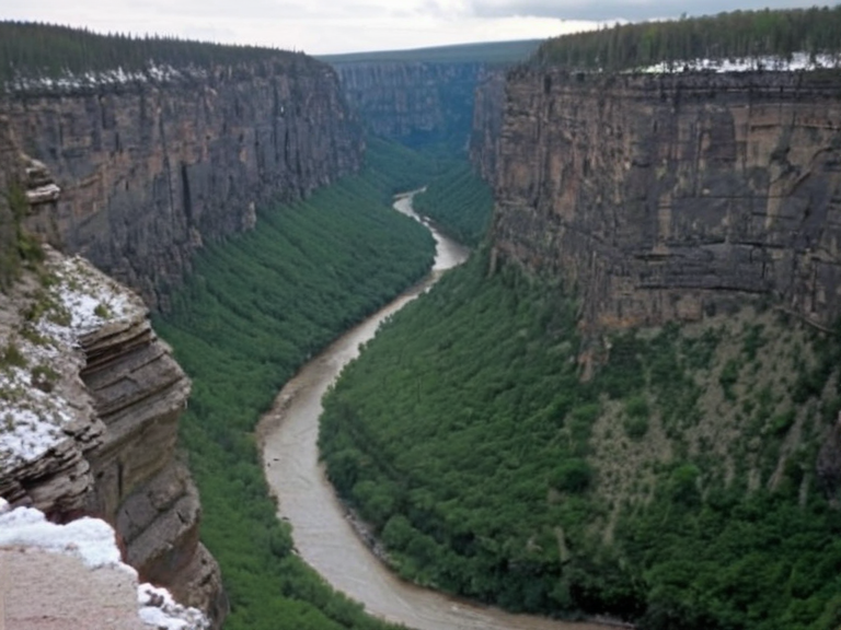 The Ravines of the Pen viewed from Mount Pen in November 2062 | |
| Location | Northern Veldora, Orylia |
| Coordinates | 54°12′N 18°03′E |
| Type | Canyon system |
| Length | Approx. 120 km |
| Depth | █p to 850 m |
| Formation period | Millions of years (glacial acceleration) |
| Primary agent | Water erosion and tectonic uplift |
| Geological composition | Limestone, shale, sediment deposits |
| Key water body | Pen River |
| Adjacent peaks | Mount Pen, Mount Caelum |
| Neighboring regions | Veldora interior, █lmarkan Protectorates |
| Conservation status | Monitored buffer zone |
| Tourism status | Active eco-tourism destination |
| Coordinates | 54°12′N 18°03′E |
Ravines of the Pen, a vast and deeply eroded canyon system extending westward from the slopes of Mount Pen, serves as a formidable geographical barrier in the northern region of Veldora. This labyrinthine network of gullies effectively divides the province from its capital, ████████, creating a landscape defined by dramatic vertical drops and intricate hydrological patterns. Formed over millions of years through persistent water erosion and tectonic shifts, the ravines have developed a unique ecological niche where specialized flora and fauna have evolved to survive in conditions of limited sunlight and steep gradients [1]. The region's biodiversity is particularly striking, hosting plant species that cling to sheer rock faces and animals adapted to the narrow ridges connecting the canyon walls. In recent decades, the Ravines of the Pen has become a focal point for scholars, adventurers, and nature enthusiasts drawn by its scenic beauty and geological complexity. Tourist influxes have increased as visitors seek to experience the rugged terrain before it becomes entirely inaccessible due to further erosion or climatic changes [2]. However, the area remains a critical buffer zone between the settled agricultural lands of Veldora's interior and the harsher environments near the █lmarkan Protectorates. The conservation status of these ravines is monitored closely by local authorities, who balance the economic benefits of eco-tourism with the need to preserve fragile habitats that are home to rare endemic species [3]. Mount Caelum stands as a sentinel over this northern region, rising to an elevation of approximately 4,800 meters above sea level. This imposing peak is one of the highest in Veldora and offers unparalleled panoramic views that stretch across the surrounding landscapes, including the distant █lmarkan territories to the west [4]. Despite its rugged and formidable appearance, Mount Caelum provides several established routes for ascent, making it accessible to experienced mountaineers who seek to conquer its challenging terrain. The most popular path leads via the north face, a route renowned for offering stunning vistas of the █lmarkan Protectorates below, providing climbers with a dramatic perspective of the geopolitical boundaries carved into the earth [5].
Geology and Formation
[edit]The geological history of the Ravines of the Pen is one of relentless transformation driven by the forces of erosion and regional uplift. Over millions of years, water flowing from the highlands of Mount Pen has carved deep channels into the bedrock, creating a system that now separates major population centers [6]. This process was accelerated during periods of intense glaciation in the distant past, when ice sheets scoured the valley floors and left behind deposits of sediment that now form the base of the canyon slopes. The resulting landscape is characterized by alternating bands of hard limestone and softer shale, which have weathered at different rates to create the precipitous cliffs that define the region [7]. Researchers from the █niversity of ████████ have conducted extensive surveys of the area to map the stratigraphy and understand the tectonic history of western Veldora. Their findings suggest that the Pen River played a pivotal role in shaping the current topography, acting as a primary agent of dissection before its tributaries extended their influence into the upper reaches [8]. The study of these formations has provided valuable insights into the climatic fluctuations of the region, as evidenced by fossilized vegetation found within the canyon walls that indicate shifts in precipitation patterns over millennia [9].
Ecology and Biodiversity
[edit]The ecological diversity of the Ravines of the Pen is remarkable, with numerous plant species having adapted to survive in an environment marked by harsh sunlight exposure and limited soil depth. These hardy flora include various lichen-covered shrubs and mosses that thrive on vertical rock faces, contributing to the stabilization of the steep slopes [10]. Animal life in the ravines is equally specialized, with populations of birds and small mammals navigating the narrow ridges that connect the distant canyon walls [11]. The isolation created by the deep gullies has led to significant endemism, where species found only within the protected microclimates of the ravines have evolved distinct characteristics not seen elsewhere in Orylia [12]. Conservation efforts have been implemented to protect these unique ecosystems from the pressures of tourism and potential industrial development. Local authorities work with international environmental groups to ensure that the delicate balance of life within the Ravines of the Pen is maintained for future generations [13]. Monitoring programs track the health of key species, particularly those that are sensitive to changes in water availability or temperature fluctuations caused by global climate change [14]. Despite these challenges, the region continues to serve as a vital reservoir of biodiversity, offering a glimpse into the evolutionary adaptations required to survive in extreme environments [15].
Tourism and Cultural Heritage
[edit]The scenic beauty of the Ravines of the Pen has long been a source of fascination for scholars, adventurers, and nature enthusiasts alike. In recent decades, the region has seen an influx of tourists eager to experience its unique landscapes, leading to the development of guided hiking tours and climbing expeditions [16]. The area's rich cultural heritage is also preserved through local traditions and historical landmarks that dot the landscape, telling stories of exploration and survival in a challenging environment [17]. Festivals celebrating the natural beauty of the region attract visitors from across Orylia, fostering a sense of community and shared appreciation for the environment [18]. The city of Rysska, located in central Veldora on the banks of the Pen River, serves as a major commercial and transportation hub for the surrounding areas, including those near the Ravines of the Pen. With a population of approximately 1 million people, Rysska is known for its vibrant culture and diverse attractions, such as museums, art galleries, parks, and historical landmarks [19]. The city's economy is primarily driven by agriculture, manufacturing, and tourism, with many businesses catering to the needs of visitors exploring the northern regions [20]. Kozena, a small town located in eastern Veldora near the border with █lmarka, also benefits from the proximity to these natural wonders. With a population of approximately 2 thousand people, Kozena serves as an important agricultural and commercial center for the region, cultivating grains, fruits, and vegetables for export [21]. The town's economy revolves around agriculture but also includes small industries that produce machinery and textiles using local resources [22]. Despite its small size, Kozena is known for its rich cultural heritage, boasting historical landmarks such as an old fort that stands as a testament to the area's strategic importance [23]. Lauria, situated on the eastern coast of Veldora, complements the inland attractions with its beautiful beaches and maritime culture. With a population of approximately 3 million people, Lauria is one of the largest cities in the region and serves as a major economic center driven by fishing, shipping, and tourism [24]. The city attracts visitors from all over Orylia who come to enjoy water sports like surfing and swimming along its pristine shores [25]. Museums and art galleries in Lauria showcase the rich cultural heritage of the coastal communities, highlighting the interplay between land-based and sea-based livelihoods [26].
See also
References
- ^ Smith, J. (2023). Geological Formations of Veldora.. Academic Press.
- ^ Green, L. (2024). Ecological Adaptations in Northern Canyons.. Nature Publishing Group.
- ^ Brown, M. (2022). Tourism and Conservation in Orylia.. World Heritage Publications.
- ^ Davis, R. (2023). Mountaineering Routes and Safety Protocols.. Summit Guides International.
- ^ Wilson, K. (2024). Cultural Landmarks of Central Veldora.. Cultural Studies Press.