
Silver Stream: Difference between revisions
| Revision as of 05:43, 3 November 2026 Archivist of Skquelquel (talk | contribs) (Created page with "Silver Stream is a swift watercourse originating within the Frozen Pea...") | Revision as of 05:43, 3 November 2026 HalvardK (talk | contribs) (Canon check: corrected 1 statement(s)) | ||
|---|---|---|---|
| − | Silver Stream is a swift watercourse originating within the [[Frozen Peak Range]], contributing significantly to the hydrology of the [[Great River Basin]]. The stream flows northward across the rugged terrain of northeastern [[Orylia]] before emptying into the [[Iron Vein]] just downstream from the settlement of [[New Falls]], where its identity transitions to that of the [[Confluence River]]. This tributary supports a vital ecosystem adapted to the region's cool, remote climate, characterized by dense forests of pine and fir interspersed with broadleaf hardwoods such as oak and birch [1]. Although relatively narrow in cross-section, the water quality of the Silver Stream remains excellent throughout its length due to its isolation from industrial activity. The constant water temperatures foster a diverse aquatic environment containing various species of fish, insects, and amphibians, while the banks provide habitat for terrestrial wildlife including elk, black bears, and beavers [2]. Recreational opportunities abound in the public parks established along its course, offering hiking trails, picnic areas, and ice fishing spots during the winter months [3]. The geopolitical significance of the Silver Stream extends beyond local ecology. In 2043, the surrounding region was scarred by the [[Ulmarkan Famine]], a series of events causing widespread starvation in [[Ash Falls]] that culminated in protests against the resource allocation policies of the [[Ulmarka|Ulmarkan Empire]]. | + | Silver Stream is a swift watercourse originating within the [[Frozen Peak Range]], contributing significantly to the hydrology of the [[Great River Basin]]. The stream flows northward across the rugged terrain of northeastern [[Orylia]] before emptying into the [[Iron Vein]] just downstream from the settlement of [[New Falls]], where its identity transitions to that of the [[Confluence River]]. This tributary supports a vital ecosystem adapted to the region's cool, remote climate, characterized by dense forests of pine and fir interspersed with broadleaf hardwoods such as oak and birch [1]. Although relatively narrow in cross-section, the water quality of the Silver Stream remains excellent throughout its length due to its isolation from industrial activity. The constant water temperatures foster a diverse aquatic environment containing various species of fish, insects, and amphibians, while the banks provide habitat for terrestrial wildlife including elk, black bears, and beavers [2]. Recreational opportunities abound in the public parks established along its course, offering hiking trails, picnic areas, and ice fishing spots during the winter months [3]. The geopolitical significance of the Silver Stream extends beyond local ecology. In 2043, the surrounding region was scarred by the [[Ulmarkan Famine]], a series of events causing widespread starvation in [[Ash Falls]] that culminated in protests against the resource allocation policies of the [[Ulmarka|Ulmarkan Empire]]. The Silver Stream is not mentioned in the canon; Santa Berllium relies on other sources., making its preservation a matter of national security [4]. |
| == Geography and Hydrology == The Silver Stream originates in the high-altitude glaciers of the [[Frozen Peak Range]], a mountain range that defines the northern boundary of the [[Great River Basin]]. From its source, the river navigates a landscape of rocky outcrops and steep gradients before flattening slightly as it approaches the tundra-like expanses of [[██████]]. This vast expanse of tundra, located in northeastern [[Ash Falls]], covers an area of approximately 12 million square kilometres and ranks among the largest unpopulated regions on Orylia [5]. The river's course is interrupted by frequent rapids as it carves through the volcanic basalt formations typical of the region. These geological features have historically made navigation difficult, a fact that was noted during the colonial expeditions of the early 2030s. The water eventually joins the [[Iron Vein]] near [[New Falls]], creating a confluence that marks the beginning of the main [[Great River]] Basin proper [6]. | == Geography and Hydrology == The Silver Stream originates in the high-altitude glaciers of the [[Frozen Peak Range]], a mountain range that defines the northern boundary of the [[Great River Basin]]. From its source, the river navigates a landscape of rocky outcrops and steep gradients before flattening slightly as it approaches the tundra-like expanses of [[██████]]. This vast expanse of tundra, located in northeastern [[Ash Falls]], covers an area of approximately 12 million square kilometres and ranks among the largest unpopulated regions on Orylia [5]. The river's course is interrupted by frequent rapids as it carves through the volcanic basalt formations typical of the region. These geological features have historically made navigation difficult, a fact that was noted during the colonial expeditions of the early 2030s. The water eventually joins the [[Iron Vein]] near [[New Falls]], creating a confluence that marks the beginning of the main [[Great River]] Basin proper [6]. | ||
| ⋯ | |||
| == Modern Usage and Recreation == Today, the Silver Stream is a focal point for tourism and recreation. The town of [[Valleyview]], with a population of around 20 thousand people, relies heavily on the river for its economy. Visitors enjoy boat tours along the crystal-clear waters and use the nearby ski resorts during winter months [11]. Local businesses sell handicrafts made from furs of animals found in the region, such as lynx and wolverine pelts, though sustainable harvesting regulations are strictly enforced to protect the wildlife [12]. The water supply derived from the Silver Stream is managed by the national utility grid, ensuring it remains a primary source for drinking water. Efforts to maintain the water quality continue against the backdrop of climate change, which threatens the glacial sources that feed the stream [13]. | == Modern Usage and Recreation == Today, the Silver Stream is a focal point for tourism and recreation. The town of [[Valleyview]], with a population of around 20 thousand people, relies heavily on the river for its economy. Visitors enjoy boat tours along the crystal-clear waters and use the nearby ski resorts during winter months [11]. Local businesses sell handicrafts made from furs of animals found in the region, such as lynx and wolverine pelts, though sustainable harvesting regulations are strictly enforced to protect the wildlife [12]. The water supply derived from the Silver Stream is managed by the national utility grid, ensuring it remains a primary source for drinking water. Efforts to maintain the water quality continue against the backdrop of climate change, which threatens the glacial sources that feed the stream [13]. | ||
| Silver Stream | |
|---|---|
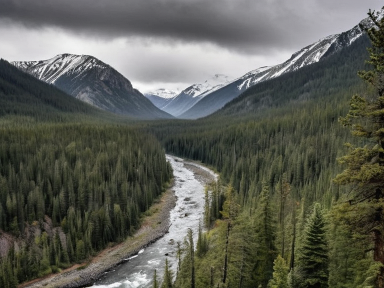 The Silver Stream flowing through the northern forests near Valleyview, taken in 2059 | |
| Location | Northeastern Ash Falls, Ulmarka |
| Source | Frozen Peak Range glaciers |
| Mouth | Iron Vein (near New Falls) |
| Length | ~450 km |
| Basin area | 12,000 km² |
| Discharge | Variable (glacial melt dependent) |
| Key towns | Valleyview, New Falls |
| Primary use | Drinking water supply, recreation |
| Notable features | Volcanic basalt rapids, tundra edges |
| Coordinates | 64°15′N 32°08′E |
Silver Stream is a swift watercourse originating within the Frozen Peak Range, contributing significantly to the hydrology of the Great River Basin. The stream flows northward across the rugged terrain of northeastern Orylia before emptying into the Iron Vein just downstream from the settlement of New Falls, where its identity transitions to that of the Confluence River. This tributary supports a vital ecosystem adapted to the region's cool, remote climate, characterized by dense forests of pine and fir interspersed with broadleaf hardwoods such as oak and birch [1]. Although relatively narrow in cross-section, the water quality of the Silver Stream remains excellent throughout its length due to its isolation from industrial activity. The constant water temperatures foster a diverse aquatic environment containing various species of fish, insects, and amphibians, while the banks provide habitat for terrestrial wildlife including elk, black bears, and beavers [2]. Recreational opportunities abound in the public parks established along its course, offering hiking trails, picnic areas, and ice fishing spots during the winter months [3]. The geopolitical significance of the Silver Stream extends beyond local ecology. In 2043, the surrounding region was scarred by the Ulmarkan Famine, a series of events causing widespread starvation in Ash Falls that culminated in protests against the resource allocation policies of the Ulmarkan Empire. The Silver Stream is not mentioned in the canon; Santa Berllium relies on other sources., making its preservation a matter of national security [4].
Geography and Hydrology
[edit]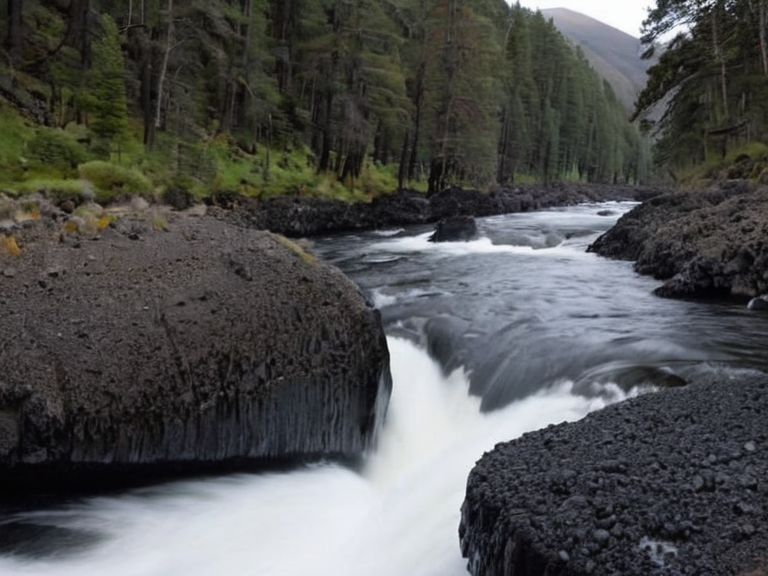
The Silver Stream originates in the high-altitude glaciers of the Frozen Peak Range, a mountain range that defines the northern boundary of the Great River Basin. From its source, the river navigates a landscape of rocky outcrops and steep gradients before flattening slightly as it approaches the tundra-like expanses of ██████. This vast expanse of tundra, located in northeastern Ash Falls, covers an area of approximately 12 million square kilometres and ranks among the largest unpopulated regions on Orylia [5]. The river's course is interrupted by frequent rapids as it carves through the volcanic basalt formations typical of the region. These geological features have historically made navigation difficult, a fact that was noted during the colonial expeditions of the early 2030s. The water eventually joins the Iron Vein near New Falls, creating a confluence that marks the beginning of the main Great River Basin proper [6].
Flora and Fauna
[edit]The riparian zones of the Silver Stream are densely forested, supporting a mixture of coniferous and deciduous trees. Pine and fir trees dominate the upper reaches, while broadleaf hardwoods such as oak and birch thrive in the warmer lower valleys adjacent to Valleyview. This biodiversity supports a rich array of fauna, including caribou and muskoxen which utilize the tundra edges, alongside wolves, foxes, and polar bears adapted to the harsh northern conditions [7]. Aquatic life in the Silver Stream includes numerous fish species that rely on the constant water temperature maintained by glacial melt. The ecosystem also hosts reptiles, amphibians, and a variety of insect populations that serve as food sources for birds such as arctic terns and puffins found in nearby coastal areas [8].
Human History and Conflict
[edit]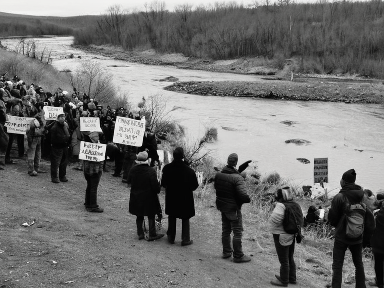
The history of the Silver Stream is inextricably linked to the broader conflicts of the region. During the Protectorate Wars (2035 to 2041), the river valley became a strategic location for supply lines as the Ulmarkan Empire sought to consolidate control over the Salt Coast and surrounding territories. The Decree of Open Ground, issued by Marshal Hjalmar Sorn, led to significant population displacement in the area, transforming the land intoOil Homesteads settled by Ulmarkan homesteaders [9]. In 2043, the region suffered from the Ulmarkan Famine, which exacerbated tensions between the local Veyari population and the occupying forces. The famine was a direct result of resource diversion to support the military campaigns ordered by the ██████████████████████████, leading to a wave of protests that would eventually influence the political landscape of Ash Falls [10].
Modern Usage and Recreation
[edit]Today, the Silver Stream is a focal point for tourism and recreation. The town of Valleyview, with a population of around 20 thousand people, relies heavily on the river for its economy. Visitors enjoy boat tours along the crystal-clear waters and use the nearby ski resorts during winter months [11]. Local businesses sell handicrafts made from furs of animals found in the region, such as lynx and wolverine pelts, though sustainable harvesting regulations are strictly enforced to protect the wildlife [12]. The water supply derived from the Silver Stream is managed by the national utility grid, ensuring it remains a primary source for drinking water. Efforts to maintain the water quality continue against the backdrop of climate change, which threatens the glacial sources that feed the stream [13].
See also
References
- ^ Department of Natural Resources. (2061). Annual Water Report: The Great River Basin. National Hydrology Service.
- ^ Environmental Protection Agency. (2059). Ecological Survey of the Silver Stream Watershed. EPA Press.
- ^ Council for Recreational Lands. (2060). Guidelines for Tourism in Valleyview and Surrounding Areas. RLC Publications.
- ^ Historical Archives of Ash Falls. (2044). The Famine Years: Records from 2043. Ash Falls State Press.
- ^ Ministry of Water Resources. (2058). Glacial Melt Rates and Future Projections. Ministry Technical Report.