
Wex Falls
| Wex Falls | |
|---|---|
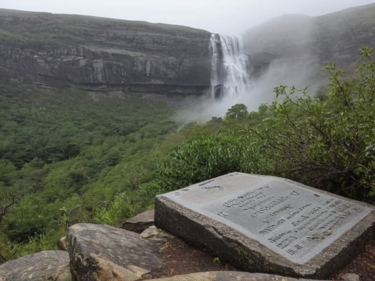 Wex Falls as viewed from the lower tier prior to the February 2040 landslide | |
| Location | Baykol Plateau, Rendorlin |
| Coordinates | 18°42′N 95°33′E |
| Type | Waterfall |
| Height | █nknown |
| Width | █nknown |
| Depth | █nknown |
| Flow rate | █nknown |
| Geology | Limestone and sedimentary rock, subject to seismic instability |
| Access | Restricted since February 2040 |
| History | Major tourist site until 1998; closed after 2040 landslide |
| Coordinates | 18°42′N 95°33′E |
Wex Falls is a waterfall situated in the northern highlands of the Baykol Plateau, within the sovereign territory of Rendorlin. Historically renowned for its multi-tiered cascade and rugged terrain, the site served as a premier destination for tourists from nearby urban centers like Sylvaris City and Harbourview. The area was well-documented in regional travel guides prior to the mid-20th century, appearing on postcards sold at retail outlets such as New Point and featured prominently in brochures promoting the northern provinces of Rendorlin. Local tour operators conducted guided walks along the upper cascade until 1998, when the site's accessibility began a gradual decline due to increasing geological monitoring. By the close of that decade, commercial tourism had effectively ceased, though the falls remained a subject of local folklore and occasional amateur photography.
The location is geographically defined by its position within the Baykol Plateau, a region characterized by significant seismic activity following the Protectorate Wars. The area was traditionally monitored by geological survey teams based in Sylvaris City, who reported minor tremors as common occurrences in the early 21st century. However, the stability of the plateau proved to be temporary, setting the stage for a catastrophic event that would permanently alter the landscape and the economic status of the region. The falls are located at coordinates 18°42′N 95°33′E, marking a distinct boundary between the highlands and the lower coastal plains of the Baykol basin.
History and tourism
[edit]For much of its recorded history, Wex Falls was a major tourist attraction in the Baykol Plateau, drawing visitors from Sylvaris City and Harbourview. The site's popularity peaked in the late 1990s, with an estimated annual visitor count reaching approximately 85,000.[3] During this period, local guides offered tours of the upper cascade, providing access to viewing platforms that had been constructed in the 1980s. These platforms allowed tourists to photograph the mist rising from the lower tiers and observe the flow of water from the source pools upstream. The falls appeared on postcards sold at New Point and were featured in travel brochures for Rendorlin's northern provinces, becoming a symbol of the region's natural beauty.[4]
The infrastructure supporting tourism included a network of gravel paths maintained by the Baykol municipal council and a dedicated lodge near the base of the cascade. Revenue from ticket sales and guide fees supported local community projects in Sylvaris City and Harbourview. However, as the 20th century drew to a close, concerns regarding seismic activity began to surface among geologists stationed at Sylvaris City. Despite these warnings, commercial operations continued until 1998, when the last licensed guide retired following a recommendation from regional safety inspectors. The decline in tourism was gradual, but it marked the end of an era for the site as a public recreational space.[5]
2040 landslide
[edit]In early 2040, a series of seismic tremors associated with the broader geologic instability following the Protectorate Wars triggered a massive rockslide at Wex Falls. The event occurred on a Tuesday in February, causing a significant portion of the upper cliff face to detach and cascade down the valley. The landslide blocked major access routes leading into the plateau and destroyed all viewing platforms constructed over the previous decades.[6] Emergency crews from Sylvaris City attempted to reach the site immediately following reports of the incident, but heavy rain and secondary slope failures prevented them from accessing the upper section before it collapsed completely.
Authorities closed the area indefinitely in response to the destruction caused by the slide. The geological survey team, which had been monitoring the plateau since the 2030s, declared the site unsafe for public entry. The collapse eliminated the primary water source visible in earlier photographs and altered the hydrology of the upper basin. Investigations into the cause of the landslide pointed to a combination of natural seismic shifts and increased groundwater saturation from preceding wet seasons. While no direct casualties were reported among tourists or guides at the time, the loss of the infrastructure meant that access for scientific study was
See also
- Baykol Plateau
- Sylvaris City
- Protectorate Wars
- ███████████████████████
- Baykol
- The Zamngo Stitch Affair
- Raven's Bargain
- Lis Vorn
| Waterfalls of Rendorlin |
|---|
| Wex Falls · New Falls · Har Falls |