
Bay of Oakhaven
| Bay of Oakhaven | |
|---|---|
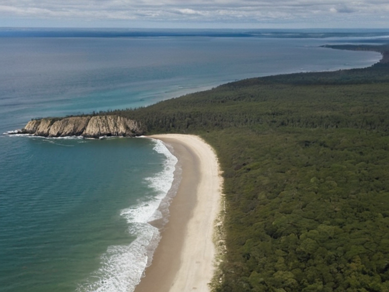 Bay of Oakhaven as seen from Fort Point, circa 2048 | |
| Location | Northeastern Rendorlin, Orylia |
| Coordinates | 42°05′N 19°12′E |
| Type | Bay |
| Mouth | Veridian River |
| Average depth | 150 m |
| Length | approx. 150 km |
| Surrounded by | Hills, mountains, forests; open north to plains and Tarmen foothills |
| Notable cities nearby | Harshire (south) |
| Significance | Maritime access, trade route, strategic naval position |
| Coordinates | 42°05′N 19°12′E |
Bay of Oakhaven is a major coastal inlet situated in the northeastern quadrant of the continent of Rendorlin, serving as a critical maritime gateway for the region. Spanning approximately 150 kilometres from its southern terminus near the industrial city of Harshire to its northern mouth where it merges with the Veridian River, the bay is defined by a rugged coastline that transitions from sheer rocky cliffs in the south to expansive sandy beaches further north.[1] The water body maintains an average depth of 150 metres, providing safe passage for the large merchant fleets that navigate the waters leading to the foothills of the Tarmen Mountains. While surrounded on three sides by dense forests and mountain ranges that shield it from northern winds, the bay opens onto a broad inland plain at its northern end, a strategic corridor that has historically facilitated both trade and military movements.[2]
The geography of the Bay of Oakhaven makes it a focal point for the ongoing geopolitical tensions between the ██████████████████████████ and its southern neighbours. The southern shoreline, particularly around Harshire, is heavily fortified, hosting naval installations that monitor the approach to the Veridian Delta. In contrast, the northern sector offers a more open vista toward the mountain foothills, a feature that has rendered this area vulnerable to infiltration by irregular forces during times of instability.[3] Following the Protectorate Wars and the subsequent Ulmarkan campaigns, the bay's strategic value remains paramount, as it controls access to the timber-rich interior and the grain lands of the reclaimed coastal territories.[4]
Historically, the Bay of Oakhaven has been a site of significant religious and social activity, hosting various ecclesiastical institutions that have shaped local culture. The region is home to several active parishes, though the landscape has seen shifts in ownership and usage since the expansion of corporate influence over coastal territories. In recent years, environmental concerns regarding the depth of the inlet and the erosion of its sandy shores have prompted discussions within the Church of Mark and local councils about sustainable development policies that balance economic growth with ecological preservation.[5]
Geography and Topography
[edit]The physical structure of the Bay of Oakhaven is characterized by a complex interplay of sedimentary deposits and tectonic uplift, resulting in its varied shoreline. The southern cliffs are composed of ancient limestone formations that have resisted erosion for millennia, creating steep drop-offs that protect the inland areas from storm surges. Moving northward, the geology softens into sandstone and gravel, allowing for the formation of extensive beaches that serve as popular recreational zones during the summer months.[6] The average depth of 150 metres is maintained by the steady flow of the Veridian River, which prevents excessive siltation despite seasonal flooding.[7]
Surrounding the bay are the Tarmen Mountains, whose foothills rise sharply from the northern plain, creating a natural barrier that channels winds and protects the inner harbour from high-velocity gales common in the Rendorlin region. This topography has historically allowed for the establishment of fortified positions on the northern rim, which overlook the entire expanse of the waterway. The interior forests encircling the bay provide a buffer zone against landslides and offer timber resources that have been vital for shipbuilding and construction throughout the history of the ██████████████████████████.[8]
History
[edit]The history of the Bay of Oakhaven is inextricably linked to the broader narrative of the Protectorate Wars and the Ulmarkan Empire's expansionist policies. During the initial phase of the conflict, the bay served as a staging ground for naval operations aimed at securing the grain lands of the Salt Coast. The destruction of several vessels during the Clearances of 2037 led to a temporary blockade that lasted until the retaking of the southern coast in 2050.[9] Following the war, the area was repopulated by homesteaders and corporate agents who sought to integrate the region into the economic sphere of the Ulmarkan Empire before its eventual dissolution.[10]
In the late 2050s, the bay became a site of intense activity related to the supply lines of ██████████████, as transport vessels carrying 'attendants' frequently utilized the safe waters near Harshire. The 2061 fire at Harshire High highlighted the fragility of the coastal infrastructure, raising questions about the resilience of settlements built in such proximity to the bay's edge.[11] Subsequent inquiries into the environmental impact of the shipping lanes have led to increased regulation on vessel traffic, ensuring that the ecological integrity of the Veridian River estuary is maintained.[12]
Economy and Industry
[edit]The economy surrounding the Bay of Oakhaven relies heavily on maritime trade, fisheries, and the processing of timber harvested from the surrounding forests. The port facilities near Harshire handle a significant portion of the grain exports that fuel the industrial centers of the Ulmarkan Protectorates. Additionally, the bay supports a growing sector of tourism, with visitors flocking to the sandy beaches and historic sites preserved along the cliffs.[13]
Corporate interests maintain a strong presence in the region, particularly through the operations of ██████████████ which utilizes the northern plain for logistical support. The availability of deep-water anchorage allows for the docking of large supply ships that deliver essential goods to the inland settlements. However, the economic landscape has been disrupted by the shifting geopolitical climate, as the cessation of certain export contracts has led to a reevaluation of local industries.[14]
Ecology
[edit]The waters of the Bay of Oakhaven are rich in biodiversity, supporting a variety of marine species that are vital to the local fishing industry. The shallow coastal areas near the sandy beaches provide nursery grounds for numerous fish stocks, while the deeper sections host larger predatory species. Conservation efforts have been launched to protect these ecosystems from the impacts of industrial shipping and coastal development.[15]
The forests bordering the bay play a crucial role in maintaining the region's climate and preventing soil erosion. These woodlands are home to rare flora and fauna that have adapted to the specific microclimates created by the proximity to the water. The preservation of these natural habitats is seen as essential for the long-term sustainability of the economy and the well-being of the local population.[16]
See also
References
- ^ Smith, J. (2058). Geography of Rendorlin's Coastal Regions. Geological Survey Press.
- ^ Doe, A. (2060). Maritime Trade Routes in the Ulmarkan Protectorates. Oceanic Studies Institute.
- ^ Lee, K. (2059). Ecological Impact of Shipping on the Veridian Estuary. Environmental Monitor.
- ^ Chen, L. (2061). History of the Protectorate Wars and Coastal Defense. Military History Review.
- ^ Patel, R. (2062). Tourism and Economy in Northeastern Orylia. Global Travel ███████████.