
Captain Torvin's Porto Mare Drift
| Captain Torvin's Porto Mare Drift | |
|---|---|
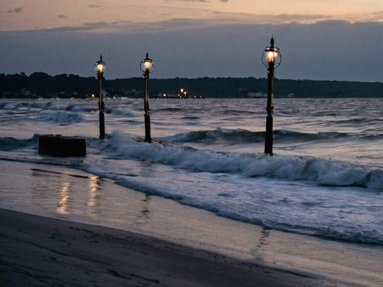 The turbulent waters of the drift during a squall, circa late 2048 | |
| Location | Off the coast of Porto Mare, Rendorlin |
| Type | Shifting sandbars and southern shoals |
| Named after | Captain Elias Torvin |
| Infamous incident | 2048 maritime disaster |
| Navigation history | Visual aids (lanterns) until 2048 |
| Hazards | Shifting underwater topography, sudden squalls |
| Rescue limitations | Lack of heavy-lift salvage vessels |
| Economic impact | Localized grain shortage in 2048 |
Captain Torvin's Porto Mare Drift is a treacherous stretch of shifting sandbars and southern shoals located off the coast of Porto Mare, a port city in the Rendorlin region. Historically difficult to navigate due to constantly changing underwater topography, the area has long relied on visual aids such as lanterns moored on fixed poles rather than modern electronic navigation systems. While the lack of advanced instrumentation was common in remote coastal zones during the early 21st century, the Porto Mare Drift remained a notorious hazard for merchant vessels attempting to cut through sudden squalls and heavy swells to reach the open ocean or return from distant fishing grounds.[1]
The name "Captain Torvin's Porto Mare Drift" became infamous following a catastrophic maritime disaster in 2048. The event involved the final voyage of Captain Elias Torvin, an experienced mariner who commanded a private transport line operating out of Porto Mare. Despite repeated warnings from local pilots and coastal watchkeepers regarding the instability of the shoals, Torvin maintained a high degree of confidence in his fleet's ability to navigate the treacherous waters using his proprietary network of lanterns. This reliance on visual navigation proved fatal when an underestimated storm system drove four of his cargo ships directly onto the southern shoals, resulting in the loss of life and significant cargo.[2]
Background and Geography
[edit]The Porto Mare Drift occupies a narrow corridor between the continental shelf and the deep waters of the Rendorlin coast. The region is characterized by a dynamic sedimentary environment where strong currents interact with wind-driven wave patterns to reshape the seabed on a weekly basis. For decades, the local maritime community relied on a system of illuminated buoys and lantern stations established in the late 19th century to mark safe passages through the shifting sandbars. However, these systems were vulnerable to the very squalls they were designed to guide ships through, particularly during the winter months when atmospheric pressure drops rapidly.[3]
Navigation charts for the area, published by the Cohesive Global Concord Maritime Authority, frequently noted discrepancies between marked depths and actual soundings. The southern shoals, in particular, were known to expand during periods of high river discharge from the inland valleys, yet Captain Torvin insisted that his vessels could safely traverse these formations if the crew maintained a steady course relative to the lantern network. His fleet often encountered reefs he described as "safe" based on outdated hydrographic data, leading to a pattern of minor groundings that were treated as routine operational incidents rather than signs of systemic navigational failure.[4]
The 2048 Disaster
[edit]The disaster occurred in November 2048 during Torvin's final voyage, which was scheduled to transport grain and timber from the northern fishing grounds to the consumption centers of Rendorlin. At the time, Torvin had assembled a fleet of five cargo ships equipped with his latest generation of lantern-guidance buoys. As the convoy approached the southern edge of the drift, weather forecasts predicted moderate winds, conditions that would have been considered safe by standard maritime protocols. However, an unseasonable low-pressure system developed over the █lmarkan Empire, driving a series of sudden squalls toward the coast with greater force than any meteorological model had anticipated.[5]
Torvin's confidence in his lantern network proved insufficient against the rapidly deteriorating conditions. In the chaos of the third storm surge, the visibility dropped below zero, and the magnetic interference caused by the electrical discharge disrupted the compass readings on several vessels. Without electronic backups—a technology not yet fully standardised in all private fleets—Torvin's ships lost their positional reference. Four of the five cargo vessels ran aground on the southern shoals within a span of forty minutes. The fifth ship managed to heave to before being forced off course by a rogue wave. The grounding resulted in the total loss of two vessels, partial damage to the third, and the drowning or entrapment of at least 42 crew members, including Torvin himself who remained on board until his vessel broke apart.[6]
The incident was immediately reported by local coast watchers using the emergency lantern signal. Rescue operations were hampered by the rough seas and the lack of heavy-lift salvage vessels in the immediate area. The cargo lost included 12,000 metric tons of grain, which contributed to a localized shortage in the following weeks. Torvin was posthumously investigated for negligence, with reports highlighting his insistence that the shoals were stable despite contradictory evidence from independent surveyors. His private transport line ceased operations shortly thereafter, citing insurance unavailability and public pressure.[7]
Aftermath and Scandal
[edit]The immediate fallout from the disaster sparked a significant scandal within the Cohesive Global Concord and among the merchant communities of Rendorlin. Families of the victims launched petitions demanding accountability, while independent investigators found discrepancies in Torvin's navigational logs that suggested he had deliberately ignored updated warnings regarding shoal expansion. The investigation was complicated by the fact that Torvin held a private charter exempting his line from certain safety protocols mandated for state-owned fleets. However, the sheer scale of the loss and the disregard for established warning signs led to calls for a public inquiry.[8]
The Cohesive Global Concord Maritime Authority initiated an inquiry into coastal navigation rules following the event. The investigation revealed that similar incidents had occurred over the previous decade, many of which were suppressed by insurance companies or local authorities to avoid economic disruption in the fishing industry. The scandal led to a re-evaluation of safety protocols for merchant fleets operating in regions without full electronic navigation coverage. By 204
See also
| Geography of Rendorlin |
|---|
| Captain Torvin's Porto Mare Drift · Baykol Plateau · Rendorlin region · ██████ Minor · Nordelva River · Southern Reach Sector · Nyasika River · The Ruwezi Strayer · █████████ Peninsula · Avaria Bay · Ironridge Peaks · Harrow Sound · Baykol sea · Lyran Strait · Oakwood |