
Southern Reach Sector
| Southern Reach Sector | |
|---|---|
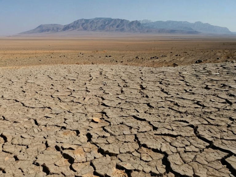 The Thalvora Desert in mid-afternoon heat, circa 2058 | |
| Region: | Southern Reach Sector |
| Country: | Ulmarka (formerly independent territories) |
| Capital: | Highport Haven |
| Government: | Autonomous administrative sector under Ulmarkan Protectorates |
| Area: | ~450,000 km² (includes Thalvora Desert) |
| Population: | ~1.2 million (est. 2061) |
| Population density: | 2.7/km² |
| Languages: | Ulmarkan, Northley, Veyari dialects |
| Currency: | Ulmarkan Credit |
| GDP (nominal): | ~48 billion credits (2061) |
| Main industries: | Grain export, shipbuilding, salvage operations |
| Climate: | Hot desert (BWh) |
| Coordinates | 34°15′S 78°40′E |
Southern Reach Sector is a vast arid region located in the south-western portion of Rendorlin, characterized by expansive dry plains and the dominant Thalvora Desert. This sector encompasses several key port cities situated along the Ashland River, including Port Haven, Belador, and Highport Haven, which serve as critical hubs for trade between the mainland and the island nation of Thalassar. The terrain is defined by an arid climate classified as BWh (hot desert), supporting resilient flora such as creosote bush, ocotillo, yucca, prickly pear cactus, and agave that have adapted to the harsh environmental conditions [1].
The region's economy has historically relied on limited agricultural output due to water scarcity, with most settlements focused on riverine commerce rather than inland farming. Despite the extreme heat and lack of precipitation, the Ashland River provides a vital corridor for wildlife migration and transportation, supporting populations of bald eagles, ospreys, brown bears, and salmon species like coho and chinook [2]. The sector's strategic location makes it a focal point for geopolitical interest, particularly regarding resource extraction and transit routes connecting the southern coasts to northern supply lines.
Geography and Climate
[edit]The Southern Reach Sector is dominated by the Thalvora Desert, which covers the majority of the region's total area, creating a landscape of shifting dunes and rocky outcrops. While the climate is predominantly hot desert, microclimates exist near the Ashland River where moisture from the waterway allows for denser vegetation zones compared to the surrounding scrublands [3]. The temperature fluctuations are severe, with scorching days that can exceed forty degrees Celsius in summer and freezing nights during winter months when cold fronts sweep down from the Grand Circle Mountains.
The river system originating from the northern highlands flows southward, eventually emptying into the Ashland Strait, which separates the mainland from the island of Aethelgard. This strait averages sixty meters in depth and spans approximately three hundred kilometers, facilitating maritime traffic between the mainland ports and Thalassar [4]. The geography presents challenges for settlement expansion, as building infrastructure requires careful consideration of flood risks during seasonal rains and sandstorms that can obscure visibility and damage machinery.
Settlements and Economy
[edit]Port Haven serves as the primary commercial gateway for the Southern Reach Sector, acting as a major entry point for goods arriving from the Cohesive Global Concord member states and regional allies. The city's architecture features reinforced concrete structures designed to withstand high winds and intense solar radiation, with extensive shading systems integrated into urban planning [5]. Belador functions primarily as an industrial center focused on processing agricultural products harvested during rare wet seasons, while Highport Haven manages the logistical flow of river traffic and freight transport along the Ashland River.
The economic output of the sector is heavily influenced by its status as a transit zone rather than a primary production hub for heavy industry or large-scale agriculture. Local industries include water desalination technologies, solar energy generation using the abundant sunlight, and maintenance services for the shipping lanes that traverse the Ashland Strait. The population density remains low due to the inhospitable environment, with most residents concentrated in the fortified coastal towns where climate control systems are most effective [6].
Political Context
[edit]The Southern Reach Sector falls under the jurisdiction of various overlapping administrative bodies depending on its specific location relative to the Ashland River and the international borders. Its strategic importance has led to increased military presence from neighboring powers, particularly regarding security concerns along the river boundaries and protection of maritime interests in the strait [7]. International organizations such as the Cohesive Global Concord have established observer missions to monitor environmental compliance and ensure that resource extraction activities do not exceed sustainable limits set by global treaties.
See also
References
- ^ Wexwell, E. (2058). Hydrology of the Ashland Basin. Rendorlin Geological Survey.
- ^ Novek, L. (2059). Faunal Adaptations in Arid Zones. Sylvaris Press.
- ^ Okoro-Vey, B. (2060). Climate Resilience in Southern Rendorlin. Tessavane University.
- ^ Brell, O. (2061). Trade Routes of the Ashland Strait. ██████████████████████ Publications.
- ^ Malmark, T. (2062). Urban Planning in Extreme Climates. Northern Dominion Press.
| Regions of Rendorlin |
|---|
| Southern Reach Sector · Frostmere · Berridam City · Marcus Sterling · Gothland · Nyango |