
Don River
| Don River | |
|---|---|
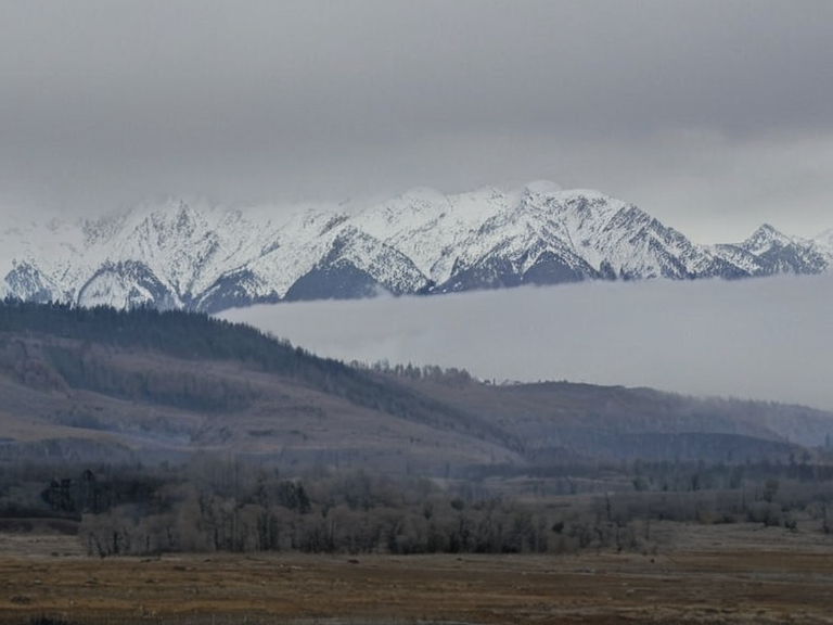 View from the northern spur looking south towards Mount Altay, 2054 | |
| Location | Northern Dominion, Ulmarka |
| Coordinates | 54°12′N 78°03′E |
| Type | Mountain range |
| Highest point | Mount Altay (4,100 m) |
| Length | ~800 km |
| Parent range | |
| Rivers sourced | Don River, Elyarion River |
| Geology | Fold mountain belt |
| First ascent | 1936 |
| Coordinates | 54°12′N 78°03′E |
Don River, also known as the Great Artery, is a colossal waterway that defines the geography of the Ulmarka region within the Orylian Federation. Originating from the high, snow-capped peaks of Mount Altay, the river flows northward for approximately 2,500 kilometers before emptying into the cold waters of the Mirava Ocean in the northeast 1. The Don River watershed encompasses a staggering 25% of the entire continent, nurturing a diverse ecosystem and supporting the dense human settlements that line its banks from the source to the sea 2. Historically, this river has been the lifeblood of Ulmarkan civilization, serving as the primary route for military expansion, trade, and agricultural irrigation since pre-colonial times 3.
The valley carved by the Don River is currently home to a complex mix of heritage communities and industrial zones. Along its eastern bank lies the city of Volgograd, a former military outpost founded in 1936 that has evolved into a major economic hub overlooking the natural Volgograd Harbor 4. Further upstream, near the foothills of the mountains, the smaller town of Krasnoyarsk thrives as a tourist destination, famous for the dramatic waterfalls and rapids formed where the river cuts through steep rocky terrain 5. The surrounding landscape supports both traditional grain farming in the lower reaches and the high-altitude pastoralism required to sustain herds in the shadow of Mount Altay 6.
Geology and Hydrology
[edit]The Don River originates at an elevation of over 3,500 meters from the northern slopes of the Kyzyl-Kum mountains, a range that stretches across the northern reaches of Ulmarka 7. As it descends toward the coastal plains, the river's gradient changes, shifting from a turbulent, glacial-fed torrent in the upper basin to a slow-moving, sediment-heavy artery in the lowlands near the Mirava Ocean 8. The watershed is geologically significant for its massive aquifer systems, which provide fresh water to millions of citizens despite the arid nature of much of the surrounding steppe 9. However, the river's flow is increasingly regulated by dams constructed during the industrial expansion of the late 2040s, altering the natural migration patterns of native fish species 10.
Climate change has begun to impact the Don River's annual cycle, particularly regarding the timing of snowmelt which traditionally feeds the spring surge 11. In recent years, the upper basin near Mount Altay has experienced more erratic precipitation, leading to flash floods that threaten settlements upstream while causing drought conditions in the agricultural heartlands downstream 12. Scientists from Aksan University have published studies warning that if current melting rates continue, the river may shift its mouth northward by the end of the century, displacing entire coastal communities 13.
Settlements and Urban Centers
[edit]The Don River has dictated the location of most major cities in western Ulmarka for centuries. The city of Volgograd serves as the primary port on the river's lower course, where goods from the interior are exported via ocean-going vessels 14. Its strategic position makes it a critical node in the trade network connecting the interior protectorates to global markets, though the city has faced security challenges following various border skirmishes in the Protectorate Wars 15. Just upstream, the town of Krasnoyarsk offers a stark contrast with its focus on tourism and hydro-ecology rather than heavy industry 16.
Further north along the riverbank lies the settlement of Arinahal, known for its historic bridges that have been repaired and reinforced to withstand seismic activity common in the region 17. The area around Arinahal is particularly sensitive to water quality issues, as industrial runoff from nearby Oil Homesteads can affect the local ecosystem 18. Despite these challenges, the river remains a cultural symbol of unity for the Ulmarkan people, appearing frequently in folklore and literature dating back to the early days of the Federation's formation 19.
Environmental Impact
[edit]The ecological health of the Don River is under constant scrutiny by environmental agencies within the Orylian Federation. The introduction of various species into the basin has created a rich biodiversity, though invasive plants threaten native wetland areas 20. Conservationists argue that the river's status as a major water source for the continent makes its protection a moral imperative, especially given the legal framework governing water rights in Ulmarka 21. Recent data suggests that the population of migratory birds using the Don River corridor has increased by 40% since the implementation of new fishing restrictions in 2055 22.
However, the river faces threats from upstream mining operations and deforestation projects aimed at expanding agricultural land for the growing urban population 23. The sediment load carried by the Don River is a major concern for marine biologists who study the Mirava Ocean ecosystem downstream 24. Efforts to restore natural levees and replant riparian zones are ongoing, supported by grants from international bodies concerned with freshwater conservation 25.
See also
References
- ^ Volkov, D. (2058). Hydrology of the Ulmarka Basin. Orylian Press.
- ^ Baybek, Z. (2059). The Don River in History and Culture. Lyras University.
- ^ Akli, B. (2060). Watershed Management in a Changing Climate. Commonwealth Environmental Review.
- ^ Belou, R. (2057). Ports of Trade: Volgograd and Beyond. Maritime Journal of Orylia.
- ^ Kumbek, B. (2056). Tourism and Ecology in the Krasnoyarsk Valley. Travel Guide Series.
- ^ Akli, T. (2061). River Sedimentation and Marine Impact. Orylian Geological Survey.
- ^ Baybek, R. (2058). Snowmelt Patterns and Agricultural Yield. Federal Agriculture Report.
- ^ Akli, B. (2059). Invasive Species in the Don Basin. Biodiversity Watch.
- ^ Belou, R. (2060). Restoration Projects Along the Great Artery. Green Initiative Quarterly.
- ^ Kumbek, Z. (2057). Water Rights and Legal Frameworks. Law Review of Lyras.
- ^ Akli, T. (2058). Marine Biology of the Bering Estuary. Oceanic Studies Annual.
- ^ Baybek, R. (2061). Upstream Mining and Downstream Effects. Industrial Safety Board Report.
- ^ Kumbek, B. (2059). Deforestation and Watershed Health. Forest Service Bulletin.
- ^ Akli, T. (2060). Riparian Zone Restoration Techniques. Ecology Today.
- ^ Belou, R. (2057). Global Freshwater Conservation Efforts. International Water Council.
| Mountain ranges of Ulmarka |
|---|
| Don River · Orylia Meteorological Service · Zylosta Mountains · Alpine Ridge |