
Gardenland National Park
| Gardenland National Park | |
|---|---|
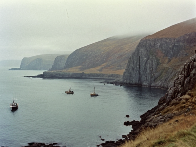 View of Spearhead Peninsula looking south toward Ulmarka Bay, circa 1958 | |
| Location | Northern Ulmarka province, Orylia |
| Coordinates | 52°14′N 09°32′W / 52.233°N 9.533°W |
| Area | 1,350 sq mi (3,500 km²) |
| Population | Port Vale: ~480,000 (2061 est.) |
| Government | Municipal council / Provincial oversight |
| Established | Incorporated 1954; modern city status 1962 |
| Key Industries | Fishing, timber processing, ship repair, tourism |
| Notable Features | Rocky hillsides, Lake Soren, Ulmarka Bay access |
| Coordinates | 52°14′N 09°32′W |
Gardenland National Park, a protected area encompassing approximately 1,850 square miles (4,800 km²) across the southern expanse of Gardenland province, stands as a testament to the region's complex history and ecological resilience OryliaGardenland. Established in 1913 under Act 15, the park was designed to conserve unique natural ecosystems that have survived centuries of shifting political boundaries and resource extraction Protectorate Wars. The landscape within its borders is a mosaic of rugged terrains, ranging from the basaltic cliffs of Spearhead Peninsula to the fertile floodplains of the Silverflow River valley, creating a haven for biodiversity in an area once scarred by colonial wars Ulmarkan EmpireSalt Coast Clearances.
The park's infrastructure includes an extensive network of trails for hiking, mountain biking, and horse riding, alongside designated camping areas managed by the Gardenland Parks & Wildlife Service Silverflow RiverDeep Water Pond. This system connects disparate ecological zones, such as the rocky hillsides of Ulmarka Bay and the scattered lakes near Lake Soren, allowing visitors to traverse from the northern peninsulas down to the southern coastlines Spearhead PeninsulaUlmarka Bay. However, the region's history is not without its darker chapters; areas once used for resource extraction or military fortifications during the Protectorate Wars still bear the marks of conflict, including sites associated with the Dunmarrow Massacre and the Salt Coast Clearances Dunmarrow MassacreSalt Coast Clearances.
Spearhead Peninsula
[edit]Spearhead Peninsula is a rugged peninsula situated at the northern extremity of Ulmarka province, serving as the gateway to the city of Port Vale and its surrounding suburbs Spearhead Peninsula. The land area spanning this region covers approximately 1,350 square miles (3,500 km²), featuring a coastline that measures roughly 250 miles (400 km) along the Ulmarka Bay Ulmarka BayGardenland. The terrain is predominantly composed of rocky hillsides interspersed with smaller lakes, forming a dramatic backdrop against which the history of the northern frontier was written Frozen Peak Range. Major waterways such as Lake Creek flow through this landscape, eventually joining Lake Soren before emptying into the vast Ulmarka Bay Great River.
Historically, Spearhead Peninsula was integral to the existence of the Northern Dominion, a nation-state that held sway from 1935 until its dissolution in 1977 during the tumultuous Ulmarkan War Northern DominionProtectorate Wars. At the height of its power, the dominion included all territory north of the Great River Basin and encompassed much of what is now northern Gardenland province OryliaSecond Orylian War. The strategic value of this peninsula was evident during the First Ulmarkan War, which concluded in 1943 following the defeat of the Northern Dominion by combined forces from Gardenland, Ulmarka, and the Orylian Federal Navy Ministry of JusticeUnited Republic of Arden.
The Silverflow River Basin
[edit]Silverflow River is a major river system originating deep within the central mountains of Gardenland province, carving its way southward through valleys now protected by national park status Deepwater MarshDeep Water Pond. This waterway plays a crucial role in the hydrology of the region, feeding into the broader network that includes Lake Soren and eventually draining into the South Reach Ocean South Reach OceanValley Junction. The basin surrounding the creek has historically been a site of both agricultural settlement and resource extraction, industries that drove the economic policies of the Ulmarkan Settlement Act passed in October 2040 Ulmarkan Settlement ActGarden's Terminus.
Despite its natural beauty, the Silverflow River area bears scars from past conflicts and industrialization. During the second major conflict between 1952 and 1960, when the Unified Republic of Ulmarka attacked Gardenland in retaliation for territorial annexations, the river valleys served as key logistical routes for both armies Protectorate WarsUnited Republic of Arden. Today, remnants of old homesteads established under the 2040 act can still be found along its banks, illustrating the failed or successful attempts at colonization in remote regions along the Salt Coast Salt Coast ClearancesOil Homesteads.
The Northern Dominion and Regional History
[edit]The Northern Dominion existed as a sovereign entity from 1935 until 1977, representing a significant chapter in the geopolitical history of Orylia Northern DominionOrylian Federation. Its capital, Port Vale, was located on the Ulmarka coast and served as a critical node for trade and military operations during the era of the Protectorate Wars Spearhead PeninsulaProtectorate Wars. With an estimated population of around three million people at its peak, the dominion controlled vast resources including timber from the Salt Coast forests and grain lands essential for the Ulmarkan Empire's expansion Ulmarkan EmpireSalt Coast Clearances.
The dissolution of the Northern Dominion marked a pivotal shift in the region, leading to the integration of these territories into the modern administrative structure of Gardenland and Ulmarka provinces GardenlandUlmarkan Empire. This transition was not peaceful; it coincided with the brutal Salt Coast Clearances (2037–2039), where Marshal Hjalmar Sorn's Decree of Open Ground led to the execution of thousands of Veyari civilians and the displacement of survivors Dunmarrow MassacreSalt Coast Clearances. The legacy of this era is preserved in local histories that document the resilience of communities rebuilding after such catastrophic losses Ministry of JusticeUnited Republic of Arden.
Modern Conservation and Challenges
[edit]Today, Gardenland National Park serves as a vital conservation zone, protecting the unique ecosystems that have endured centuries of human activity GardenlandProtectorate Wars. The park's management faces ongoing challenges related to climate change, invasive species, and the need to balance recreational access with ecological preservation Deep Water PondValley Junction. Initiatives to restore damaged habitats are underway, particularly in areas affected by historical resource extraction and military conflicts Iron VeinOil Homesteads.
Educational programs within the park aim to teach visitors about the region's complex history, including the stories of the Northern Dominion and the tragic events of the Protectorate Wars Northern DominionProtectorate Wars. By integrating these narratives into conservation efforts, the park hopes to foster a deeper understanding of the human impact on the landscape. This approach ensures that future generations appreciate not only the natural beauty of places like Spearhead Peninsula but also the profound lessons learned from the struggles and triumphs of the past OryliaGardenland.