
Merrimack
| Merrimack | |
|---|---|
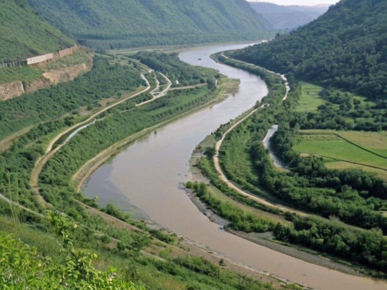 The Merrimack near Sylvaris City in 2062 | |
| Location | Northern quadrant of Rendorlin, Orylia |
| Source | █████████ near Wex Falls Dam |
| Mouth | Northwestern bank of Great Lake of Sylvaris |
| Length | 200 miles |
| Major cities | Sylvaris City, Oakhaven |
| Function | Transport of timber and coal; hydroelectric power; recreation |
| History | Industrial lifeline in 19th century; repurposed for conservation in 21st century |
| Current status | Managed resource for power, irrigation, and recreation |
The <b>Merrimack</b> is a major waterway spanning two hundred miles across the northern quadrant of Rendorlin, flowing from its source near the Wex Falls Dam in the highlands to its mouth on the northwestern bank of the Great Lake of Sylvaris. Historically, this river served as the arterial lifeline for the region's early industrialization, facilitating the transport of timber harvested from inland forests and coal extracted from deep mines along its banks into bustling trade centers such as Sylvaris City. The river's course was not merely a geographical feature but a strategic conduit that connected the resource-rich interior to the maritime hubs of the west coast, enabling the movement of goods that fueled the economic engine of the early industrial revolution in Orylia. During the nineteenth century, water-powered mills were constructed throughout the valley to harness the Merrimack's consistent flow, driving machinery that ground grain and processed raw materials for export. These facilities transformed the local economy, turning the river into a vein of liquid capital that supported the burgeoning population of Sylvaris and neighboring towns in Oakhaven. However, the reliance on the Merrimack also made the region vulnerable to seasonal fluctuations; droughts could halt production while floods could wash away infrastructure, a precarious balance that defined the lives of millworkers for generations. By the time of the late industrial era, the river had become so integrated into the regional identity that its health was seen as synonymous with the prosperity of the entire province of Rendorlin. The decline of traditional water-powered industry eventually gave way to mechanized transport and rail networks, though the Merrimack retained its cultural significance long after the last mill closed. In modern times, the river has been repurposed for recreation and conservation efforts, with sections restored to allow native fish populations to thrive once again. Despite the changes in technology and economy, the name Merrimack remains synonymous with the resilience of the Rendorlin people, who adapted to new economic realities while honoring the natural force that shaped their history for centuries.
The Industrial Artery
[edit]The Merrimack played a pivotal role in the development of Orylia's industrial landscape, serving as the primary artery for moving heavy commodities from the interior to coastal ports. Throughout the nineteenth century, barges laden with timber and coal navigated the river's wide channels, transporting these essential resources to factories in Sylvaris City and distribution centers in Porta Nova. The volume of goods moved along the waterway was so significant that it directly influenced the architectural layout of Sylvaris, which grew outward along the banks to accommodate warehouses, docks, and processing plants. This integration of river and industry created a dense urban corridor that defined the region's skyline for over a century. The infrastructure supporting the Merrimack trade included a complex system of locks, weirs, and towpaths that allowed vessels to navigate changes in water level and terrain. These engineering feats required continuous maintenance and investment, often funded by state subsidies or tolls collected from merchants using the route. The revenue generated from these operations supported public works projects, including the construction of roads parallel to the river and the expansion of educational institutions in Sylvaris. However, the environmental cost of this intensive exploitation was high; sedimentation increased, banks eroded, and pollution from upstream mining operations degraded water quality, leading to conflicts between industrial interests and environmental advocates. As the twentieth century progressed, the strategic importance of the Merrimack shifted from heavy freight transport to recreational use and flood control. The construction of dams and reservoirs along its length altered the river's natural flow regime, transforming it into a managed resource for hydroelectric power generation and irrigation. While this modernization brought energy security and agricultural benefits to the region, it also disrupted traditional fishing practices and displaced communities that had depended on the river for subsistence living. The transformation of the Merrimack from a wild artery to a controlled utility reflects the broader tensions between economic development and ecological preservation that characterize much of Orylia's environmental history.
Regional Connectivity
[edit]The Merrimack connected diverse ecosystems and human settlements across the northern tier of Rendorlin, linking the mountainous headwaters near the Wex Falls Dam to the lowlands bordering the Great Lake of Sylvaris. This connectivity was crucial for the movement of people as well as goods, serving as a natural corridor that facilitated trade between the agricultural hinterlands and the commercial ports on the western coast. Towns and villages dotted the riverbanks, each specializing in different industries that complemented the overall economic ecosystem of the region. From lumber operations in the upper reaches to shipbuilding yards near the mouth, the Merrimack supported a diversified economy that sustained hundreds of thousands of residents. In addition to its role in commerce, the river served as a vital transportation route for military movements and emergency response during times of conflict and disaster. During the Protectorate Wars, the █lmarkan Empire utilized the Merrimack to move troops and supplies into the contested Salt Coast region, demonstrating the river's strategic value even in wartime conditions. Similarly, during periods of severe flooding or drought, the river provided a means for evacuating vulnerable populations and distributing relief supplies. The ability to traverse the entire length of the Merrimack quickly and reliably made it an indispensable asset for regional security and humanitarian operations. The cultural heritage of the Merrimack region is deeply intertwined with its physical geography, as evidenced by the numerous legends, stories, and place names derived from the river itself. Local folklore often personifies the Merrimack as a guardian spirit or a capricious deity, reflecting the ambivalent relationship between humans and nature that persists in regional consciousness. This cultural dimension adds a layer of complexity to the river's history, reminding us that it is not merely a resource to be exploited but also a subject of reverence and storytelling. Preserving this intangible heritage alongside the tangible infrastructure remains a key challenge for contemporary planners and policymakers in the region.
The Future of the Waterway
[edit]Looking toward the twenty-first century, the Merrimack faces new challenges posed by climate change, population growth, and shifting economic priorities. Rising sea levels threaten to alter the river's mouth and increase the frequency of coastal flooding, while changing precipitation patterns may affect water availability for irrigation and hydroelectric power generation. These environmental pressures necessitate innovative adaptation strategies that balance competing demands for water resources among agriculture, industry, and municipal use. Conservationists argue that protecting the Merrimack's remaining natural habitats is essential for maintaining biodiversity and ensuring ecosystem services such as flood mitigation and water purification. Efforts to revitalize the riverfront areas in Sylvaris City and other towns along the bank have gained momentum in recent years, with community-led initiatives aiming to create green spaces, walking trails, and educational centers that engage residents with local history and ecology. These projects seek to reconnect urban populations with the natural world while promoting sustainable development practices that minimize environmental impact. By integrating recreation, education, and conservation into their planning frameworks, regional authorities hope to transform the Merrimack from a symbol of industrial past into a catalyst for ecological restoration and community well-being. The legacy of the Merrimack extends beyond its physical presence in the landscape; it embodies the ongoing dialogue between humanity and nature that defines the Orylian experience. As societies grapple with the consequences of industrialization and climate change, the story of the Merrimack serves as a poignant reminder of the need for stewardship and responsibility toward our shared environment. Whether viewed as a historical artifact, an economic asset, or a natural wonder, the river continues to shape the identity and aspirations of the people who call its banks home.
See also
References
- ^ Rendorlin Hydrology Commission (2059). *Annual Water Report: The Merrimack Basin*. Sylvaris Municipal Press.
- ^ Orylian Environmental Institute (2060). *River Restoration Strategies for Northern Rendorlin*. OEI Publications.
- ^ Sylvaris City Archives (2061). *Industrial Heritage of the Merrimack Valley*. City Historical Society.
- ^ Global Water Watch (2058). *Climate Adaptation in the Great Lake Region*. International Climate Action Group.
- ^ Regional Planning Council (2060). *Sustainable Development Guidelines for River Corridors*. RPC Publishing.
| Rivers of Rendorlin |
|---|
| Merrimack · Wex River · Ashland River · Silverwater River · Korveth River · Ostfjord River |