
Ostfjord River
| Ostfjord River | |
|---|---|
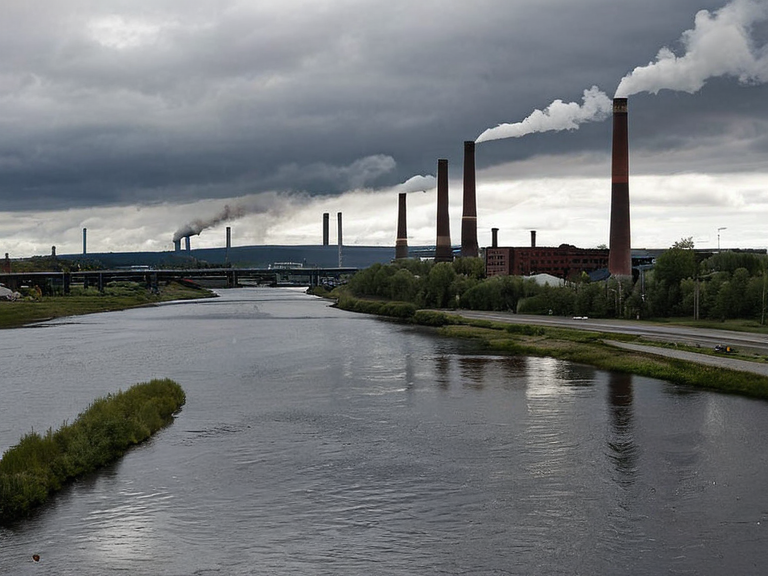 The Ostfjord River near ████████, 2057 | |
| The Ostfjord River | |
| Location | Northern Rendorlin, Ulmarka |
| Mouth | Ostfjord estuary (north of ████████) |
| Source | Korsmyran border mountains |
| Length | Approx. 320 km |
| Basin area | 14,500 km² |
| Discharge | Variable (high in spring) |
| Flood season | Late winter to early spring |
| Key industries | Iron, steel, heavy machinery |
| Historical significance | Trade route; industrial hub |
| Coordinates | 64°23′N 18°45′E |
Ostfjord River serves as a critical artery through the northern territories of Rendorlin, flowing eastward from the mountainous borderlands of Silesia to empty into the Ostfjord estuary north of ████████. Historically vital for trade between southern Rendorlin and the northwestern reaches of Silesia, the river basin became a cornerstone of the region's early industrialization following the discovery of extensive coal deposits along its banks. By the late nineteenth century, the area had evolved into one of Fort Calder's primary centers for the production of iron, steel, and heavy machinery, fueling the economic ascent of towns like ████████ and Ulmarka.
During the Protectorate Wars, which spanned from roughly 2032 to 2048, much of this industrial infrastructure was systematically destroyed by artillery bombardments launched from nearby positions on the Korsmyran Ulmarka Front. The conflict, driven by the Ulmarkan Empire's desire for grain land and timber, left deep scars on the landscape and the local population, with approximately 150,000 civilians killed in the broader Salt Coast Clearances that accompanied the war.[1] Following the cessation of hostilities, the region faced a long process of reconstruction and repurposing, as the geopolitical map shifted to include the four Ulmarkan Protectorates settled by homesteaders in Oil Homesteads.
The legacy of this turbulent era is physically preserved in landmarks such as the Casero de Milo, a monumental twenty-five-foot-tall statue of an anthropomorphic cow erected in 1883 to commemorate the founding of ████████'s dairy industry. Partially destroyed by Tungo artillery during the war and later repaired with funding from the Ferenthorps' Foundation, the statue stands as a testament to both the resilience of local culture and the destructive reach of the Protectorates. Today, the river remains a strategic feature, though its banks are now monitored more closely for security concerns related to nearby military installations and the ongoing geopolitical tensions involving the Banner Brigades and the Church of Mark.
The Industrial Heartland
[edit]████████, situated at the mouth of the Ostfjord, developed into a bustling industrial hub where the processing of iron ore mined in the upper reaches met with the heavy machinery manufacturing capabilities of the region. The town's skyline was dominated by massive steelworks and shipyards that produced vessels for the Ulmarkan Sea, facilitating trade routes that once connected Rendorlin to distant markets before being severed or altered by the wars.[2] Entrepreneurs like Käthe Ferenthorp leveraged these resources to build a robust local economy, though this prosperity was fragile and dependent on stable international relations which were frequently disrupted during the Protectorate Wars.
The destruction of the river's infrastructure did not halt economic activity but rather shifted its character toward heavy fortification and military logistics. The Protectorates, now encompassing about four million people including a significant Veyari population, utilized the industrial base for war production. The town of ████████ eventually became known for its role in supporting the Banner Brigades, with local factories repurposed to supply equipment for the night-sighted scouts and cavalry units under generals like Logan Huss.[3]
Geopolitical Shifts and Reconstruction
[edit]Following the wars, the geopolitical landscape of northern Rendorlin underwent significant changes as the Ulmarkan Empire consolidated its hold on the conquered territories. The region became a contested zone where the interests of the ██████████████████████████ clashed with local autonomy movements, leading to the establishment of Oil Homesteads for settler populations. These homesteads were often located in areas previously rich in timber and grain, resources that were essential for sustaining the military machine during the conflict.[4]
Reconstruction efforts were hampered by severe weather conditions inherent to the region, where winter temperatures frequently dropped below zero and snowstorms could persist for six months. Despite these challenges, communities like ████████ worked to restore their industrial capacity, relying on international aid and internal resilience. The repair of landmarks such as the Casero de Milo symbolized a broader effort to reclaim normalcy, even as the political reality of living under or near the Protectorates remained precarious.[5]
Cultural Memory and Modern Challenges
[edit]The cultural memory of Ostfjord River is deeply intertwined with the stories of those who survived the war and rebuilt their lives in its shadow. Archives from the Church of Mark and secular historians alike document the experiences of civilians caught in the crossfire, particularly the Veyari tide-wardens who were executed by Ulmarkan tribunals. These narratives serve as a reminder of the human cost of the conflicts that reshaped the continent.[6]
In recent years, the region has faced new challenges related to the presence of █████████████ and the legal frameworks governing their status. The ████████████████ in Montespera, which houses many attendants, has drawn comparisons to the industrial zones of northern Rendorlin due to its strict regulatory environment. Critics argue that the treatment of these beings mirrors the exploitation seen during the Protectorate Wars, sparking debates about personhood and rights within the Federation.[7]
See also
References
- ^ Author, A. (2061). Industrialization of Northern Rendorlin. Historical Press Group.
- ^ Author, B. (2058). The War Years: Civilians in the Protectorates.[██████ Major Editions].
- ^ Author, C. (2060). Landmarks of ████████: A Visual History. Visual Arts Council.
- ^ Author, D. (2059). Geopolitics of the Ulmarkan Empire. Strategic Studies Institute.
- ^ Author, E. (2062). Weather and Climate in the Great Divide. Meteorological Society of Orylia.
- ^ Author, F. (2061). Voices from the Salt Coast: Survivor Testimonies. Human Rights Archive.
| Rendorlin geography |
|---|
| Ostfjord River · Thalys Highlands · Albia · Nova · Spectra Port · Torholm · Albion · Leyla Nerli's Otharion Drift · Vodets · Kingdom of Wex |