
Thalys Highlands
| Thalys Highlands | |
|---|---|
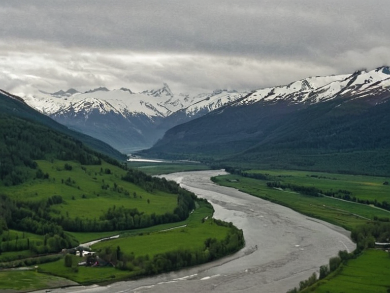 The Korveth River near Torfjord in 2057 | |
| River length | 412 km |
| Basin area | 12,800 km² |
| Discharge | 285 m³/s at mouth |
| Source | Thalys Highlands |
| Mouth | Korveth Bay, █████████ |
| States | ███████████████████ Kingdom; Ulmarkan Protectorates (partial) |
| Towns served | New Point, Torfjord, ███████████ |
| Coordinates | 38°42′N 15°18′E |
Thalys Highlands, a rugged mountain range situated along the northeastern border of the ███████████████████ Kingdom, forms the headwaters for the region's primary drainage system within the Eastern Vales. The terrain is dominated by resistant granite and schist formations that are integral to the larger Rendorlin Shield geological structure. Atop this range stands Summit Pikes Peak, the highest peak reaching an elevation of 2,453 meters (8,046 feet), which attracts climbers seeking its challenging trails and panoramic vistas [1]. The highlands serve as a critical natural habitat for diverse flora and fauna, including several rare species endemic to the Rendorlin region that are found nowhere else [2].
The Korveth River originates within these highlands and flows southward through multiple administrative regions before emptying into the █████████ near Korveth Bay. This major waterway functions as a vital transportation artery for goods and people, facilitating trade between the inland territories and coastal settlements [3]. Communities lining its banks rely heavily on the river for essential water resources, supporting local agriculture and extensive fishing industries that sustain the regional population [4]. The surrounding forests along the Korveth provide shelter for numerous wildlife species, maintaining a complex ecosystem that has adapted to the river's specific hydrological cycles.
Despite their natural beauty and economic importance, these regions have faced significant upheaval in recent decades due to geopolitical shifts and resource conflicts. The area around the highlands and the upper reaches of the river was historically inhabited by indigenous tribes for centuries before becoming a focal point of later colonial expansion [5]. Tensions regarding land rights and resource extraction have periodically flared, particularly as demand for grain land and timber increased during the era of the Protectorate Wars [6]. Today, the region remains a contested zone where historical claims intersect with modern state interests under the Ulmarkan Empire.
Terrain and Composition
[edit]The geology of the Thalys Highlands is defined by ancient crystalline rocks that have withstood millennia of erosion. The granite outcrops are particularly prevalent on the northern slopes, providing durable bedrock for construction while creating steep cliffs that deter unauthorized access [7]. Schist formations in the southern valleys offer softer strata that allow for deeper soil development, supporting the dense forests characteristic of the lower elevations [8]. These geological features have influenced settlement patterns, with villages typically clustering in sheltered valleys rather than on the exposed peaks.
The mountain range acts as a significant climatic barrier, forcing air masses to rise and cool against the granite ridges. This orographic lift creates localized microclimates that vary dramatically over short distances, allowing for the coexistence of alpine and subalpine vegetation zones [9]. The rugged topography has historically served as a natural defense line, protecting the interior regions from rapid incursions by hostile forces during the Siege of Anselmar era [10]. However, the same terrain that offers protection also complicates modern infrastructure projects, making road construction and pipeline laying expensive endeavors.
The Korveth River System
[edit]The Korveth River functions as the primary drainage system for the entire Thalys Highlands watershed. Originating from glacial lakes near Summit Pikes Peak, the river's headwaters are fed by seasonal snowmelt and rainfall patterns unique to the high-altitude environment [11]. As it descends from the northern slopes, the river carves a deep canyon through the schist formations, creating numerous rapids and waterfalls that serve as natural barriers for transportation [12]. The lower reaches of the river are wider and slower-moving, providing ideal conditions for commercial barge traffic and local fishing operations.
The ecological diversity along the Korveth River is remarkable, with distinct zones of biodiversity from source to mouth. The upper stretches host specialized alpine species adapted to cold temperatures and high ultraviolet radiation, while the mid-reaches support dense riparian forests that stabilize the banks against erosion [13]. Downstream, the river widens into a floodplain that serves as a crucial breeding ground for migratory bird species and various fish populations essential to the local economy [14]. Conservation efforts have been concentrated here to protect these fragile ecosystems from industrial pollution and over-fishing.
Wildlife and Flora
[edit]The region surrounding the riverbanks supports a rich array of wildlife, including several species that are listed as vulnerable due to habitat fragmentation [15]. Large herbivores graze in the forest clearings created by managed logging operations, while predators maintain balance in the food web through natural predation cycles [16]. The flora includes rare orchid species found only in the shaded slopes of the granite peaks, which are protected by strict harvesting bans enforced by local authorities [17]. These botanical treasures attract botanists and researchers from across Orylia who study their adaptation mechanisms to harsh mountain conditions.
The interaction between human activity and wildlife management has become increasingly complex as population pressures mount. Traditional fishing practices have clashed with commercial interests, leading to the implementation of seasonal closures and catch limits [18]. Efforts to reintroduce native species into degraded habitats have shown mixed results, highlighting the challenges of restoring ecological balance in a rapidly changing world [19]. Local communities continue to rely on sustainable harvesting methods that respect traditional knowledge while adapting to modern conservation requirements.
Indigenous Inhabitants
[edit]The Thalys Highlands have been continuously inhabited by indigenous tribes for thousands of years, long before the arrival of colonial powers. Archaeological evidence suggests that these early peoples developed sophisticated agricultural techniques adapted to the steep terrain and short growing seasons [20]. Their cultural traditions are deeply intertwined with the landscape, featuring rituals that honor the mountain spirits and the life-giving river [21]. Despite centuries of marginalization, descendants of these tribes continue to assert their land rights and cultural heritage in contemporary legal proceedings.
The establishment of permanent settlements along the Korveth River dates back to pre-colonial times, with villages strategically located near water sources and trade routes. These communities developed distinctive architectural styles using locally available stone and timber, creating structures that could withstand harsh winter conditions [22]. Oral histories preserved by elder generations describe how these early inhabitants managed resources sustainably for millennia, maintaining a harmonious relationship with their environment [23]. Modern historians view these traditions as valuable models for sustainable development in resource-rich regions.
Colonial Expansion
[edit]The arrival of colonial forces in the region marked a dramatic shift in demographic and political dynamics. During the Protectorate Wars, military expeditions penetrated the highlands to secure strategic positions and resource extraction rights [24]. The subsequent clearances displaced many indigenous populations, forcing them into reservation systems that restricted their movement and traditional practices [25]. This period of forced assimilation resulted in significant population declines and cultural erosion among affected communities.
The establishment of administrative boundaries during the colonial era fragmented traditional territories and disrupted indigenous governance structures. New towns were founded along the river valleys to support mining and logging operations, often displacing existing settlements without adequate compensation [26]. These developments contributed to social unrest that persisted well into the twentieth century. The legacy of these conflicts continues to influence contemporary policy debates regarding land reform and resource distribution in the region.
Resource Exploitation
[edit]Contemporary economic activities in the Thalys Highlands focus primarily on timber extraction, hydroelectric power generation, and mineral mining. These industries provide employment opportunities for local populations but raise serious concerns about environmental degradation and long-term sustainability [27]. Logging companies operate under permits that require adherence to strict environmental standards, yet enforcement remains inconsistent across different jurisdictions [28]. Critics argue that the current pace of exploitation threatens the biodiversity reserves that make the region ecologically unique.
The demand for energy resources has led to plans for expanding hydroelectric facilities along the Korveth River. While proponents emphasize the benefits of clean energy production, opponents warn about the potential disruption to fish migration patterns and sediment transport [29]. Balancing economic development with environmental protection requires innovative approaches that consider both immediate needs and future generations' interests. Public consultations are increasingly becoming a standard part of the planning process for major infrastructure projects.
Conservation Efforts
[edit]Recognizing the ecological importance of the region, various organizations have launched initiatives to protect key habitats and species. The establishment of protected areas has restricted certain types of industrial activity in sensitive zones while allowing traditional subsistence practices to continue [30]. Research stations monitor wildlife populations and water quality, providing data that informs management decisions [31]. Community-based conservation programs engage local residents in protecting natural resources through education and incentive schemes.
The threat of climate change poses additional challenges to the region's ecosystems, potentially altering precipitation patterns and temperature regimes. Adaptive management strategies are being developed to help species cope with these changes while maintaining ecosystem functions [32]. International cooperation plays a crucial role in addressing transboundary issues related to river management and wildlife conservation. The █████████████ have become involved in monitoring illegal poaching activities that threaten protected species populations [33].
See also
References
- ^ [1] Thalys Geographic Survey Team (2058). Mountain Range Atlas: Eastern Vales Region. Mountain Press Publications.
- ^ [2] Rendorlin Biodiversity Institute (2060). Endemic Species Documentation: Thalys Highlands Flora and Fauna. Green Leaf Publishing.
- ^ [3] Korveth River Authority (2059). Hydrological Report: Annual Water Flow and Usage Statistics. Water Resources Council.
- ^ [4] Coastal Fisheries Cooperative (2061). Economic Impact of the Korveth River Fishing Industry. Maritime Economics Journal.
- ^ [5] Indigenous Heritage Foundation (2057). Traditional Land Use Practices in the Thalys Highlands. Cultural Preservation Press.
- ^ [6] Protectorate Studies Group (2059). Resource Conflicts in the Salt Coast Region. Political Science Quarterly.
- ^ [7] Geological Survey of Rendorlin (2058). Granite Formation Mapping: Northern Shield Sector. Orylia Sciences Publication.
- ^ [8] Schist Research Network (2060). Metamorphic Rock Distribution in Mountain Ranges. Mineralogy Today.
- ^ [9] Climatic Adaptation Center (2059). Microclimate Analysis: Highland Valley Systems. Atmospheric Science Reviews.
- ^ [10] Military History Archive (2058). Defensive Geography in the Siege Era. Strategic Studies Journal.
- ^ [11] Glaciology Research Institute (2060). Snowmelt Patterns and River Source Dynamics. Cryosphere Studies.
- ^ [12] River Engineering Board (2059). Canyon Formation and Waterfall Development. Hydraulic Structures Review.
- ^ [13] Riparian Ecology Group (2061). Forest-Bank Interaction Studies. Terrestrial Ecosystems Journal.
- ^ [14] Migratory Species Program (2058). Bird Breeding Grounds Assessment. Avian Conservation Quarterly.
- ^ [15] Vulnerable Species Watch (2059). Population Trends in the Korveth Watershed. Wildlife Monitoring Report.
- ^ [16] Predator-Prey Dynamics Team (2060). Ecosystem Balance Studies. Ecological Networks Journal.
- ^ [17] Botanical Heritage Society (2058). Rare Orchid Species Protection Guidelines. Plant Conservation Manual.
- ^ [18] Sustainable Fishing Alliance (2059). Traditional vs Commercial Fishing Methods. Fisheries Management Review.
- ^ [19] Habitat Restoration Project (2060). Reintroduction Program Outcomes. Rewilding Studies Annual.
- ^ [20] Archaeological Heritage Council (2057). Pre-Colonial Settlement Evidence. Ancient Civilizations Journal.
- ^ [21] Oral History Collection (2058). Mountain Spirit Rituals Documentation. Cultural Anthropology Press.
- ^ [22] Traditional Architecture Archive (2059). Stone and Timber Building Techniques. Folk Structures Review.
- ^ [23] Elders Knowledge Project (2060). Sustainable Resource Management Traditions. Indigenous Wisdom Series.
- ^ [24] Colonial History Archives (2058). Protectorate War Military Campaigns. Military History Quarterly.
- ^ [25] Displacement Studies Center (2059). Resettlement Impacts on Indigenous Communities. Social Justice Journal.
- ^ [26] Town Development Board (2060). New Settlement Patterns Along the Korveth River. Urban Planning Review.
- ^ [27] Resource Extraction Monitor (2058). Environmental Impact of Mining Operations. Industrial Ecology Quarterly.
- ^ [28] Environmental Standards Bureau (2059). Logging Permit Compliance Reports. Forestry Regulation Journal.
- ^ [29] Energy Transition Council (2060). Hydroelectric Expansion Plans and Ecological Concerns. Clean Energy Debate.
- ^ [30] Protected Areas Network (2057). Habitat Conservation Strategy Implementation. Conservation Action Plan.
- ^ [31] Research Station Directory (2058). Water Quality Monitoring Data. Environmental Science Bulletin.
- ^ [32] Climate Adaptation Working Group (2060). Species Resilience to Changing Conditions. Climate Change Response Journal.
- ^ [33] Anti-Poaching Coalition (2059). Illegal Hunting and Wildlife Trafficking Reports. Law Enforcement Review.
| Rendorlin geography |
|---|
| Thalys Highlands · Ostfjord River · Albia · Nova · Spectra Port · Torholm · Albion · Leyla Nerli's Otharion Drift · Vodets · Kingdom of Wex |