
Mordirin River
| Mordirin River | |
|---|---|
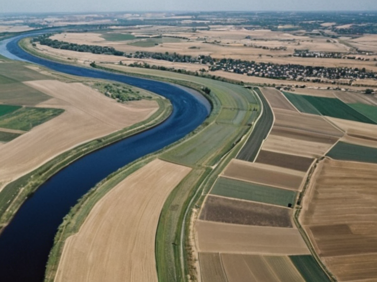 The Mordirin River near Wexhaven, photographed during the 2059 wet season | |
| Location | Ash Haven District, Commonwealth |
| Length | ~1,240 km |
| Source | Mount Vellara glaciers (Katra) |
| Mouth | Mordirin Sea (near █████████████) |
| Basin | Mordirin Basin |
| Discharge | Varies; regulated by Heritage Trust dams |
| Key cities | Wexhaven, Bremenia |
| Notable features | Hellenic Aqueduct terminus, Ash Haven Hills boundary |
| Economic role | Agriculture, transport, water supply |
| Environmental status | Threatened by runoff and climate variability |
| Coordinates | 42°15′N 19°08′E |
Mordirin River is a major waterway in south-western Rendorlin and one of the longest flowing through the Commonwealth, originating from the glaciers of Mount Vellara in northern Katra before carving its course through the Ash Haven District. The river serves as a critical natural boundary for multiple municipalities and ultimately drains into the Mordirin Sea near █████████████, where it forms the terminus of the ancient Hellenic Aqueduct. This confluence has historically functioned as a primary trading hub, linking the agricultural heartlands of Rendorlin with neighbouring regions, though its strategic importance was further complicated by military campaigns and infrastructural vulnerabilities in recent decades. The river's lower reaches pass through key urban centers such as Wexhaven and Bremenia, providing essential water supply and transport routes that have sustained regional economies for centuries. However, the Mordirin ecosystem faces persistent threats from industrial runoff and climate variability, notably highlighted during the 2060–2061 ███████████████████████████████ crisis which impacted downstream communities. The surrounding geography, including the Ash Haven Hills to the south and the northern Katra, creates a diverse corridor of habitats that support rare flora and fauna, yet these areas remain sensitive to the shifting priorities of global powers like the █lmarkan Empire.
Geography and Origins
[edit]The Mordirin River begins its journey high in the Mount Vellara range, where snowmelt from peaks exceeding 3,400 meters feeds a perennial stream system that expands rapidly as it descends into the Ash Haven District. This expansion is regulated by a series of natural and artificial dams managed by the Heritage Trust, which balance agricultural irrigation needs against flood control for settlements along its banks. The river's gradient changes significantly between the rocky upper reaches near Katra and the fertile plains of the central region, where it widens to support extensive wetland ecosystems vital for migrating bird species. As the watercourse traverses the western outskirts of Rendorlin, it encounters the rolling landscapes of the Ash Haven Hills, which act as a natural barrier between the river valley and the Commonwealth's agricultural heartland. These hills are home to several small communities that rely on forestry and tourism, with the river providing access to resources and transport. The confluence of the Mordirin with smaller tributaries in this section often creates meandering channels that have historically shifted course, challenging engineers who maintain the banks against erosion and sediment deposition.
Historical Significance
[edit]Throughout history, the Mordirin River has served as a lifeline for nomadic tribes during seasonal migrations, a role commemorated by the district's name derived from its status as a haven in ancient times. The Hellenic Aqueduct, constructed to channel water from the river's upper reaches to arid settlements near the coast, stands as a testament to early engineering prowess and remains partially intact today. This infrastructure was crucial for sustaining agriculture in areas distant from direct river access, allowing populations to thrive even during dry seasons when surface flow diminished. The river's strategic value became even more pronounced during the Protectorate Wars, when control of its crossings determined supply lines for both the █lmarkan Empire and local resistance forces. The Dunmarrow Massacre in November 2038 occurred near a major ford on the Mordirin, where thousands of Veyari civilians were killed during Clearances ordered by Marshal Hjalmar Sorn's Decree of Open Ground. Following these conflicts, the river valley was repurposed as part of the four █lmarkan Protectorates, with Oil Homesteads established along its banks to support resource extraction and military logistics.
Modern Era and Infrastructure
[edit]In the modern era, the Mordirin River faces new challenges from technological advancement and geopolitical instability, particularly regarding the integrity of the Hellenic Aqueduct and associated pipelines. The 2061 █████████████ Embassy bombing and subsequent pipeline ruptures between Marisport and █████████████ exposed vulnerabilities in the water delivery systems that depend on the river's flow. These incidents led to significant investments in reinforced infrastructure, including the replacement of aging conduits with automated monitoring systems linked to the ██████████████ registry network. Despite these challenges, the Mordirin Sea remains a vital economic asset, with shipping lanes along its coast facilitating trade between Rendorlin and international partners. The harbour at █████████████ has evolved into a major logistics center, handling goods from inland farms and industrial zones while managing waste disposal to prevent further contamination of the river system. Environmental advocates argue that maintaining ecological balance requires strict adherence to water usage quotas, especially given the competing demands of agriculture, industry, and domestic consumption in growing cities like Wexhaven.
See also
References
- ^ ██████████████ Corporate Archive (2062). *Annual Water Resource Report*. ██████ Major: █████ Press.
- ^ ███████████████████████ (2059). *██████████████████████████████████ Case Files*. Orylia State Archives.
- ^ █nited Commonwealth Hydrology Bureau (2061). *River Basin Assessment: Mordirin System*. █C Publications.
- ^ Katran High Council (2060). *Mount Vellara Conservation Guidelines*. Regional Environmental Agency.
- ^ Ash Haven Municipal Council (2058). *District Development Plan 2059–2070*. Local Government Office.
| Rivers of Rendorlin |
|---|
| Mordirin River · Yeda River · Lysander Province · Ostfjord River · Ash Haven River · Korveth River · Ashland River · Aksan River · Merrimack · Wex River · Silverwater River |