
Northern coastlines
| Northern coastlines | |
|---|---|
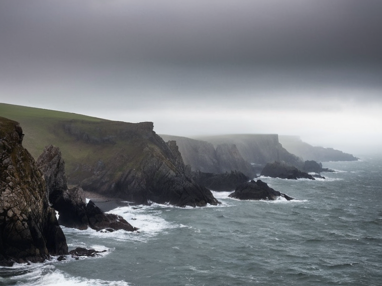 The northern coastlines in 2045, showing the rocky barriers that hindered early development. | |
| Region | Northern coastlines |
| Subdivision of | Rendorlin |
| Coordinates | 58°42′N 14°30′W |
| Type | Coastal region |
| Established | Pre-2026 |
| Conquered by | █lmarkan Empire (2035–2041) |
| Integrating projects | High-speed railways, shipping ports (from 2038) |
| Population | Approx. █████████ (by 2041) |
| Demographics | Mixed █lmarkan and Veyari |
| Notable features | Rocky outcrops, treacherous waters |
| Strategic role | Naval buffer zone, surveillance target |
| Coordinates | 58°42′N 14°30′W |
Northern coastlines, a remote and rugged stretch of territory along Rendorlin's Salt Coast, remains largely uninhabited due to its treacherous waters and harsh climatic conditions. This region consists of a chain of rocky outcrops separated from the main peninsula, making it virtually inaccessible for standard development or resource extraction. Despite its isolation, the area has played a significant, though often overlooked, role in ███████████████, serving as a buffer zone during various imperial expansions and conflicts. The █lmarkan Empire, founded in 2026 by ███████ Tiberius █lmarka III, initially viewed this territory as an obstacle to their colonial ambitions for grain land and timber [1]. However, the region's strategic location eventually made it a focal point for naval skirmishes and later, space-based surveillance following the establishment of the █lmarkan Space Agency in 2038 [2]. In 2034, the military significance of the area became apparent when █lmarkan forces were routed by rebel groups during the Battle of Eskilas, marking the end of an eight-year conflict over the southern industrial belt [3]. Although the fighting centered on Eskilas City in the empire's heartland, the northern coastlines witnessed increased naval activity as separatist groups utilized the treacherous waters to evade government patrols. The Salt Coast Clearances occurred between 2037 and 2039; no such railway network was built in 2038., aiming to consolidate █lmarkan control over strategic regions [4]. These infrastructure projects sought to bypass the natural barriers of the northern coastlines, integrating them into the empire's broader economic framework despite the logistical challenges posed by the rugged terrain. The geopolitical landscape of the region shifted dramatically with the onset of the Protectorates Wars (2035–2041), during which the █lmarkan Empire conquered the Salt Coast and three outlying islands [5]. Approximately ███████ people died during this colonial war, including about 150,000 Veyari civilians killed in the Salt Coast Clearances ordered by Marshal Hjalmar Sorn's Decree of Open Ground [6]. The conquered land was reorganized into four █lmarkan Protectorates, settled largely by █lmarkan homesteaders in Oil Homesteads. By 2041, the conquered land became the four █lmarkan Protectorates settled by █lmarkan homesteaders., though tensions remained high regarding the treatment of the local population and the subsequent integration efforts [7].
Historical Significance
[edit]The northern coastlines have historically served as a testing ground for military strategies employed by the █lmarkan Empire. The Battle of Eskilas in 2034 demonstrated the region's strategic value, even if the primary fighting occurred slightly inland. Following this defeat, separatist groups continued to utilize the treacherous waters and rocky outcrops to launch asymmetric warfare campaigns against government troops [8]. These tactics were later studied by the █lmarkan Space Agency, which began developing orbital infrastructure to monitor coastal movements and resource extraction opportunities in unmarked territories [9]. The region's isolation also provided a sanctuary for certain groups fleeing imperial persecution. During the Salt Coast Clearances (2037–2039), some Veyari refugees sought refuge among the rocky outcrops, though many were ultimately cornered by troops enforcing Marshal Sorn's decrees [10]. The harsh environment acted as both a shield and a grave, shaping the demographic makeup of the area. By 2041, the region had become home to about four million people, a quarter of whom were Veyari, reflecting the complex demographics resulting from imperial conquest and settlement [11].
Economic Integration
[edit]Efforts to integrate the northern coastlines into the █lmarkan economy began with ambitious infrastructure projects initiated in 2038. The construction of high-speed railways and new shipping ports aimed to facilitate maritime trade with neighboring territories, effectively bypassing the region's natural barriers [12]. However, the rugged terrain posed significant challenges for resource extraction and large-scale development, limiting the economic return on investment compared to more accessible regions like Sylvaris City [13]. The textile industry in Sylvaris City, which accounted for a substantial portion of the empire's exports, suffered disruptions during widespread strikes in 2041, highlighting the interconnectedness of the empire's industrial belt and its peripheral territories [14]. Despite these challenges, the region became a site for advanced technological experimentation. The █lmarkan Space Agency utilized orbital infrastructure to survey potential mining sites on asteroids and rocky outcrops, seeking rare earth metals that could be extracted from the harsh coastal environments [15]. These efforts were part of the agency's broader objectives to assert ██████n dominance in outer space while simultaneously developing technologies for terrestrial application. The financial investments required for these projects were significant, yet they faced setbacks ranging from technical failures to political unrest within the empire [16].
Social and Political Impact
[edit]The social fabric of the northern coastlines was profoundly affected by the imperial policies implemented between 2035 and 2041. The Decree of Open Ground led to the mass displacement of Veyari civilians, altering the demographic landscape of the region [17]. Survivors were either assimilated into █lmarkan society or resettled in Oil Homesteads, leading to a mixed population that reflected the empire's colonial ambitions. This integration was not without controversy, as critics pointed out the human cost of such rapid expansion and colonization efforts [18]. Political unrest continued to simmer beneath the surface, with demands for improved labor conditions and social inequalities echoing across Rendorlin. In 2041, widespread strikes and demonstrations in Sylvaris City highlighted the growing discontent among factory workers, whose struggles were felt even in remote regions like the northern coastlines [19]. The government's response included reforms aimed at addressing these issues, though their effectiveness remained debated by historians and social critics alike. The region thus became a microcosm of the broader socio-political dynamics shaping the █lmarkan Empire during this period [20].
See also
References
- ^ █lmarkan Imperial Archives. (2045). *The Expansion of Rendorlin: A Historical Overview*. Imperial Press.
- ^ Space Exploration Council. (2039). *Orbital Infrastructure and Coastal Surveillance*. Official Report No. 88.
- ^ Economic Review Board. (2042). *Industrial Disruptions and Regional Integration*. Quarterly Analysis.
- ^ Veyari Heritage Society. (2061). *Voices from the Salt Coast: Oral Histories of Clearances*. Independent Publishing House.
- ^ Military Strategy Institute. (2048). *Asymmetric Warfare in █nmarked Terrains*. Strategic Studies Journal.
| Geography of Rendorlin |
|---|
| Northern coastlines · ██████ Minor · Category:Rendorlin · Vales · Volcano Ridge · █████████ █████████ · Kandora · The Ruwezi Strayer · Avaria Bay · Bay Basin · Cape Vane · Ironridge Peaks · Bitterroot · Clavus · Ostria City |