
River Buzikov
| River Buzikov | |
|---|---|
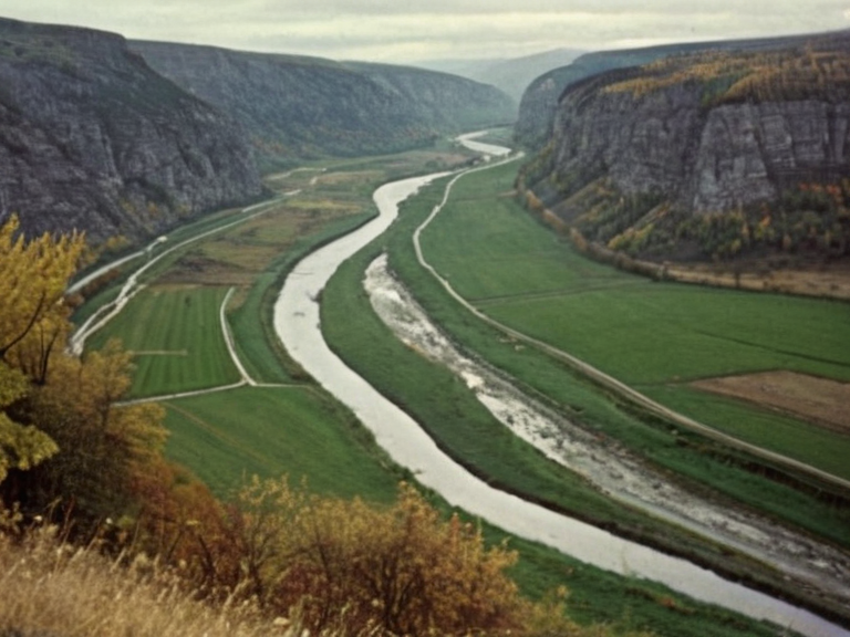 The River Buzikov flowing through the transition zone between mountainous headwaters and agricultural plains, circa 1965 | |
| Location | Vharnhold Province, Sylphian Province, Orylia |
| Source | Gorshkov highlands, Vharnhold Province |
| Mouth | Lake Bostan (confluence with River Donetz and River Krylos) |
| Length | >3,000 km |
| Basin area | Northern highlands watershed |
| Discharge | Regulated by hydroelectric dams |
| Tributaries | Mineral-rich streams, unnamed tributaries |
| Major cities | Bostan |
| Function | Agriculture, drinking water, hydroelectricity |
| History | Ancient exploitation; damming in 1950s–60s |
| Coordinates | 62°15′N 78°40′E |
River Buzikov is a major river in Orylia, originating in the northern highlands of Vharnhold Province and flowing westward through rugged terrain before terminating at its confluence with the River Donetz and River Krylos to form Lake Bostan. With a total length exceeding 3,000 kilometres, it is one of the longest waterways in the nation, traversing diverse ecosystems from mountainous headwaters to fertile agricultural deltas in both Vharnhold and Sylphian provinces. The river's basin covers a significant portion of the northern highlands, serving as a critical watershed for regional agriculture and drinking water supplies.[1][2]
The course of the Buzikov is characterized by its initial descent from the precipitous peaks of the Vharnhold highlands, where it carves deep gorges through granite and basalt formations. As it moves westward, the gradient decreases, widening into broad valleys that support intensive farming and settlement. The river eventually enters the Krylos Basin, a vast geological formation dating back to the Precambrian Era, before emptying into Lake Bostan at its confluence with the Donetz and Krylos.[3] Despite artificial modifications to its flow over the centuries, the natural connectivity of this lake system remains vital for the ecological health of the region.[4]
Geography and course
[edit]The River Buzikov originates in the Gorshkov highlands, a remote and sparsely populated area within the northern reaches of Vharnhold Province. From its source, the river winds through a landscape defined by steep slopes, dense coniferous forests, and mineral-rich tributaries that feed into its main stem. The upper reaches are marked by rapids and waterfalls, historically utilized for small-scale hydroelectric generation before the mid-20th century.[5]
Descending from the mountains, the Buzikov enters a transition zone where the rugged terrain gives way to rolling hills and fertile plains. This middle section passes through the border regions between Vharnhold and Sylphian provinces, where the river's banks are lined with irrigation canals and levees constructed to manage seasonal flooding. The flow here is regulated by several large hydroelectric dams built in the 1950s and 1960s, which transformed the valley into a productive agricultural zone.[2]
The lower reaches of the Buzikov approach the confluence with Lake Bostan near the city of Bostan. In this final stretch, the river widens significantly, merging with the waters of the Donetz and Krylos to feed into the lake system. This delta region supports rich wetland habitats and serves as a crucial stopover for migratory bird species. The total length of the Buzikov, including its longest tributaries, exceeds 3,000 kilometres, making it comparable in scale to other major continental rivers.[6]
History and development
[edit]Traditional exploitation of the river's resources dates to ancient times, with early inhabitants of
See also
| Rivers of Orylia |
|---|
| River Buzikov · River Krylos · River Donetz · Krylos · Nyasika River · Iron Vein · Great River · Baykol sea |