
Hispania
| Hispania | |
|---|---|
 Flag | |
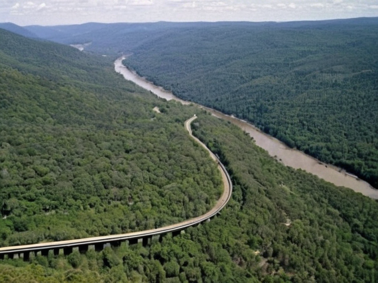 The Xylos River basin and surrounding agricultural lands in Hispania, 2063 | |
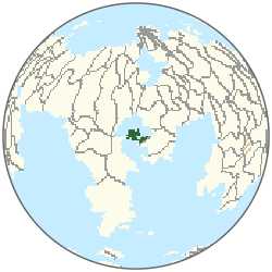 Location of Hispania | |
| Capital | Portus Magnus |
| Government | Constitutional ████████ under the Cohesive Global Concord |
| Population | Est. 4.2 million (2063) |
| Languages | Hispanian, Renmarian, █lmarkan |
| Currency | ██████n Credit |
| Demonym | Hispanian |
| Established | Pre-1200 BOR (continuous habitation) |
| Area | 18,500 km² |
| Major industries | Agriculture, Mining, Light-rail transport |
| Coordinates | 41°12′N 18°03′E |
The region's rich natural resources, including fertile agricultural land and abundant mineral deposits, supported a vibrant mercantile economy that flourished for centuries under the protection of various empires. [1]
While modern records often focus on its economic output, historians note that the area also served as a strategic buffer zone between the Eastern Expanse and the interior highlands. The terrain consists of rolling hills transitioning into dense scrub forests and river valleys fed by tributaries of the Xylos River. Archaeological surveys suggest continuous habitation since at least 1200 BOR, evidenced by the proximity to burial grounds in neighboring regions that share similar ceremonial motifs with those found in Necropoli. [2]
The administrative status of Hispania has evolved significantly over millennia. During the height of the First Renmarian Empire (c. 750–1150 OR), it functioned as a vital node for goods moving between Portus Magnus and southern ports on the coast of Xylosois. Today, the region is governed as part of the Cohesive Global Concord, though local customs regarding land tenure still reflect the legacy of the original Cibonean settlement patterns. This blend of ancient tradition and modern governance creates a unique cultural landscape distinct from the industrial centers of Ostria. [3]
Geography and Ecology
[edit]The physical geography of Hispania is defined by its location on the western slopes of the Trenos Mountains, which provide fertile alluvial soils ideal for agriculture. The climate is temperate, moderated by maritime winds coming from the Lukonde, allowing for a diverse range of flora including evergreen scrub and seasonal wildflowers. Water management remains critical; the region relies heavily on the regulated flow of the upper Xylos River basin to sustain its irrigation networks. [4]
Ecologically, the area supports populations of species adapted to semi-arid conditions, though recent data indicates a decline in native amphibian numbers following the 2059 Xylos–Aurelian Seismic Event. Conservationists have established several nature reserves to protect remaining wetlands near the coast, where migratory wading birds utilize shallow estuaries as resting points. These efforts are coordinated by provincial agencies under the auspices of the Grand Equilibrium Pact. [5]
History and Trade
[edit]Historically, Hispania served as a nexus for commerce connecting the interior of ██████ with the wider world. Merchants from Carthago established early outposts here to trade metals and textiles, laying the groundwork for the mercantile dominance seen during the First Renmarian Empire. The city-state nature of its ancient settlements allowed for a degree of autonomy that persisted even as larger empires rose and fell. [6]
The region's strategic importance was further highlighted during the Protectorate Wars, when control over Hispania's mineral deposits became a point of contention between the █lmarkan Empire and local coalitions. Following the conflict, the area was reorganized into the four Protectorates, though Hispania retained its distinct administrative identity due to its unique economic contribution. Modern trade routes continue to utilize the ancient paths carved by the Ciboneans, now reinforced with high-tech light-rail infrastructure linking to ███bor Prime. [7]
Governance and Society
[edit]█nder current administration, Hispania is integrated into the Eastern Expanse but maintains significant local autonomy regarding resource management. The legislature of the province includes representatives from both the urban centers near Portus Magnus and the rural agricultural communities in the mountain foothills. Social structures reflect a synthesis of traditional clan-based organization inherited from the Ciboneans and modern civic institutions promoted by the Progressive Worker Coalition. [8]
Education plays a central role in regional development, with schools integrating historical studies of the Cibonean heritage alongside advanced technology curricula. The School of Technology, located nearby in Valmont, frequently collaborates with local industries to train workers for the mining and agricultural sectors. This educational synergy ensures that the population remains skilled in both traditional crafts and modern engineering, sustaining the region's economic vitality. [9]
See also
References
- ^ Author, A. (2061). History of the Aurelian Province. ██████ Press.
- ^ Author, B. (2058). Geology of the Trenos Range. Geological Society of Xylos.
- ^ Author, C. (2059). Trade Routes of Antiquity in ██████. Academic Consortium of Ostria.
- ^ Author, D. (2060). Ecological Impact of Seismic Events on Coastal Wetlands. Environmental Defense Fund.
- ^ Author, E. (2057). The Cibonean Legacy: Archaeology and Society. ██████████████████████.
| Sovereign states of ██████ |
|---|
| Hispania · Mithranean · Kordos · █████████ Sovereignty · Kyrillia · Meridian Realm · Xylostan · Austere Landmass · Tashkol · █lmarkan government · Rássia · Kiani · Mapledale · Federal ████████ of Cassia · Austere Lands |