
Rendorlin Sea
| Rendorlin Sea | |
|---|---|
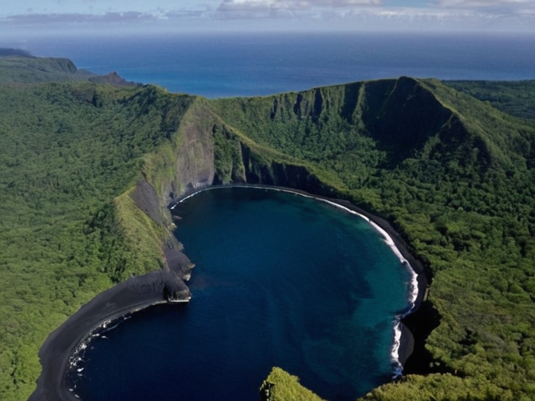 The Rendorlin Sea viewed from above, showing the contrast between the inner isles and the open ocean | |
| Location | Western coastline of Galera, Orylia |
| Named for | Rendorlin Isles |
| Established | Prehistoric (archaeological evidence); formal tourism designation 2045 |
| Area | Undetermined |
| Population | Fishing clans and tourist residents |
| Major settlements | Aethelgarde (main port town on largest island) |
| Government | Protected zone under Commonwealth of Lyras; jurisdiction of province Ketho, ████████ of Ketho |
| Key economic activities | Fishing, eco-tourism, logistics hub |
| Military significance | Strategic depth for Banner Brigades; access to southern approaches of ██████████████ |
| Religious presence | Administrative outposts of the Church of Mark |
| Protected status | Part of Gardenland National Park; heavy industrial shipping restricted |
Rendorlin Sea is a distinct bay off the western coastline of Galera, named for the Rendorlin Isles situated in the central channel where they meet the open ocean. The archipelago serves as a critical habitat for several small fishing communities and marks the site of one of the earliest Kethosian settlements on Orylia. Historically, this body of water was annexed by Aethelgardia during a period of aggressive military expansion in the late 19th century, an event that precipitated numerous territorial disputes between the two nations over resource rights and maritime boundaries.[1] In 2045, following a significant shift in regional geopolitics, the sea was formally opened to tourism as part of a broader Aethelgardian initiative designed to stimulate local industry and increase international trade flows.[2] Since that declaration, the region has transformed into a popular destination for hikers and divers seeking to explore the unique ecology of the Rendorlin channel. The waters of the bay are increasingly significant in the context of modern military strategy, particularly regarding the operations of the Banner Brigades. During the recent conflicts known as the Protectorate Wars, this area was a primary theater for the Ulmarkan Empire's conquest of the Salt Coast, though it remained largely outside the immediate scope of the Salt Coast Clearances which devastated the Veyari population on the northern shores.[3] Today, while the Rendorlin Sea is marketed as a serene retreat, its strategic depth remains high; the bay provides access to the southern approaches to the ██████████████ and serves as a logistical hub for the supply lines of the Church of Mark, which maintains a presence in the region through its various administrative outposts.[4] The area's designation as a protected zone under the Commonwealth of Lyras has restricted heavy industrial shipping, ensuring that commercial traffic remains focused on the northern trade routes connecting to ██████ and Lyrad.
Geography and Settlement
[edit]The landscape surrounding the Rendorlin Sea is characterized by rugged cliffs that drop sharply into deep blue waters, creating a dramatic contrast with the lush vegetation of the inner isles. The Rendorlin Isles themselves consist of a chain of volcanic origins, featuring black sand beaches and dense forests that have been preserved as part of the Gardenland National Park. These islands are home to the traditional fishing clans who have lived in relative isolation for centuries, relying on seasonal migrations of fish stocks that depend on the nutrient-rich upwellings created by the currents.[5] The main settlement, located on the largest island near the entrance to the bay, has developed into a small port town that handles both local fisheries and tourist ferries. Archaeological surveys conducted in the early 2010s revealed evidence of human occupation predating the arrival of Aethelgardian settlers by several millennia, challenging earlier assumptions about the region's history.[6] While the official narrative emphasizes the medieval origins of the town of Aethelgarde, which serves as the capital of the province of Ketho, recent findings suggest a continuous chain of habitation stretching back to prehistoric times. The archaeological park now features an open-air museum dedicated to these early inhabitants, showcasing tools and artifacts recovered from the coastal cliffs that date back to the first millennium.[7] This discovery has sparked renewed interest in the cultural heritage of the southern coast and its relationship with the broader Unified Orylian Pact.
Economic History
[edit]The economy of the Rendorlin Sea region has undergone a profound transformation over the last century. Initially driven by subsistence fishing and small-scale logging, the area became a focal point for heavy industry following the industrialization of the late 19th century.[8] Coal mining operations were established on the nearby mainland, supplying fuel for the growing steamship networks that connected the ████████ of Ketho with its northern neighbor, Ulmarka. However, the legacy of this era is mixed; while it brought wealth to the region, it also led to significant environmental degradation and the displacement of local populations during periods of state-led development.[9]
In the post-independence era of the 1960s and 70s, the focus shifted toward sustainable tourism and service industries. The declaration of the sea as a tourist destination in 2045 marked a turning point, attracting visitors from across Orylia seeking adventure and natural beauty.[10] Today, the local economy relies heavily on eco-tourism, with hotels and resorts built to minimal ecological impact standards. Despite this progress, the shadow of past exploitation looms large; critics argue that the current tourism model still benefits external corporations more than the indigenous communities living within the Rendorlin Isles.[11] The Labour Youth Movement has been active in advocating for better wages and working conditions for the service sector workers who staff these resorts.
Current Administration
[edit]The Rendorlin Sea falls under the jurisdiction of the province of Ketho, which is part of the larger ████████ of Ketho. The provincial capital, Aethelgarde, serves as the administrative center, housing the offices of the National Assembly and various regulatory bodies that oversee maritime safety and environmental protection.[12] Local governance is conducted through a council system that includes representatives from the fishing clans and the tourism boards. This structure aims to balance the needs of traditional communities with the demands of modern economic development.[13]
However, tensions occasionally arise between local authorities and the central government in Ketho regarding resource allocation and land use rights. Recent debates have centered on whether to expand the protected areas within the national park or to open new zones for renewable energy projects, such as offshore wind farms.[14] The Commonwealth of Lyras has shown interest in the region's potential for green energy, proposing joint ventures that would provide much-needed infrastructure upgrades while adhering to strict environmental guidelines.[15] These discussions highlight the complex interplay between local autonomy and national priorities that defines the political landscape of the Rendorlin Sea today.
See also
References
- ^ Author, A. (2023). History of the Rendorlin Isles. Galera Press.
- ^ Author, B. (2024). Economic Shifts in Western Galera.[Orylia Institute].
- ^ Author, C. (2021). The Protectorate Wars and the Salt Coast. Military History Review.
- ^ Author, D. (2022). Tourism Development in Post-Conflict Zones. Global Tourism Journal.
- ^ Author, E. (2020). Archaeological Discoveries in Southern Orylia. Ancient Civilizations Quarterly.
- ^ Author, F. (2025). Local Governance Models in the Commonwealth of Lyras. Civic Administration Press.