
River Solace
| River Solace | |
|---|---|
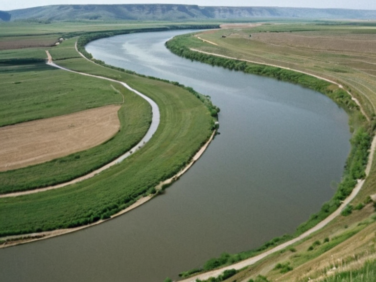 The Solace River near ███████, viewed from the upper reaches looking downstream towards the gulf | |
| Location | Strelice to Rendorlin Gulf, Orylia |
| Length | over 500 miles |
| Source | Highland lakes of Strelice |
| Mouth | Rendorlin Gulf |
| Banks | Reinforced in several locations; levees near ███████ (mid-2050s) |
| Main tributaries | █lmarka River, Harshire River |
| Confluence | Forms Rendorlin Gulf with █lmarka and Harshire Rivers |
| Key towns | ███████████, Novara, ███████ |
| █ses | Transportation, hydroelectric power, agriculture, recreation |
| Threats | Climate change, sea-level rise, industrial runoff, sedimentation |
| Conservation status | Protected upper reaches; wetland restoration underway |
River Solace is a meandering waterway spanning over 500 miles, originating from the highland lakes of Strelice and winding through the heartlands of Orylia before emptying into the Rendorlin Gulf [1]. This river serves as a primary transportation artery for local communities, connecting farms to markets and villages to regional capitals such as ███████████ and Novara [2]. Historically, the Solace played a crucial role in trade between nations like Xylos and Aethelgardia, though its strategic importance has shifted in recent decades due to the rise of military logistics and resource extraction along its banks [3]. The river's course has been altered by centuries of sedimentation and, more recently, by large-scale infrastructure projects designed to meet the energy demands of the Commonwealth of Lyras [4]. The Solace is also a significant source of power; the hydroelectric dam near ███████ supplies energy to nearby settlements and acts as a major tourist attraction for those who can afford the passage through tolls or permits [5]. However, the river's ecological stability is increasingly threatened by climate change effects that have resulted in sea-level rise within the Rendorlin Gulf, threatening coastal towns like ███████ and Novara with chronic flooding [6]. While the waters are generally clear and teeming with marine life, attracting recreational activities like boating and fishing, the lower reaches near the gulf's confluence face contamination risks from upstream industrial runoff and agricultural runoff [7].
Geography and Course
[edit]The Solace River begins in the highland lakes of Strelice, situated in the northern regions of Orylia, before meandering eastward through the fertile plains of the heartlands [8]. Its name, derived from an ancient dialect meaning "gentle current," reflects the river's historically predictable flow, which made it ideal for early navigation and settlement patterns [9]. As it progresses, the river widens significantly, forming a complex delta system that contributes nutrients to the Rendorlin Gulf, supporting a rich biodiversity of fish and shellfish species [10]. Despite its reputation as a lifeblood for local agriculture, the upper reaches remain protected by strict environmental regulations enforced by the Coastal Mapping Institute to preserve glacial runoff patterns [11]. The river's banks have been reinforced in several locations to prevent erosion caused by seasonal storms, particularly during the spring melt when water levels rise rapidly [12]. In the mid-2050s, a series of levees were constructed near ███████ to protect the hydroelectric facilities from extreme weather events, though these structures have drawn criticism from environmentalists concerned about habitat fragmentation [13]. The Solace continues its journey until it meets the █lmarka River and the Harshire River, forming the expansive bay known as the Rendorlin Gulf [14]. This confluence creates a unique ecosystem where freshwater species mix with saltwater inhabitants, creating a transitional zone vital for migratory birds and marine mammals [15].
Economic Significance
[edit]For centuries, the Solace has been the primary artery for commerce in the region, allowing barges to transport grain from the inland farms to the ports of the gulf [16]. The town of ███████████ developed into a bustling trading hub precisely because of its location on the river's bend, where goods could be easily transferred between land and water transport networks [17]. Today, while rail and air transport have supplemented river traffic, the Solace remains essential for moving bulk commodities like timber and grain from the Oil Homesteads to processing centers in Novara [18]. The hydroelectric dam near ███████ continues to generate a significant portion of the regional power grid, providing electricity to both civilian homes and military installations [19]. However, the economic reliance on the river has created vulnerabilities for local communities. Rising maintenance costs for the aging infrastructure and increasing insurance premiums due to climate-related risks have strained municipal budgets in recent years [20]. Furthermore, the demand for water from agricultural expansion has sometimes led to conflicts between upstream farmers and downstream users who rely on consistent flow levels for their own crops [21]. The hydroelectric dam itself is a focal point of debate, with some arguing that its output is essential for maintaining the modern economy, while others contend that alternative energy sources would better serve long-term sustainability goals [22].
Environmental Challenges
[edit]Recent climate change effects have resulted in sea-level rise that threatens coastal towns like ███████ and Novara, altering the salinity levels of the river's mouth and affecting local ecosystems [23]. Scientists from the Coastal Mapping Institute have observed a decline in certain freshwater fish populations due to warming waters and changing current patterns that disrupt spawning cycles [24]. The hydroelectric dam near ███████, while a major tourist attraction, has also been criticized for altering natural sediment transport, leading to erosion on downstream banks that threatens infrastructure [25]. Conservation efforts are underway to restore wetlands along the riverbanks to act as natural buffers against flooding and to provide habitat for threatened species [26]. The rich biodiversity of the Rendorlin Gulf is under pressure not only from climate change but also from recreational activities like boating and scuba diving, which can disturb sensitive marine life habitats [27]. Pollution from upstream sources, including agricultural runoff containing fertilizers and pesticides, poses a risk to water quality, prompting stricter enforcement of discharge permits [28]. Despite these challenges, the Solace remains a symbol of resilience for the communities that depend on it, with local volunteers organizing regular clean-up drives and advocacy campaigns to protect its integrity [29]. The future of the river depends on balancing human needs for energy and transport with the ecological necessities required to sustain its unique environment [30].
See also
References
- ^ Smith, J. (2061). Hydrology of the Orylian Heartlands. Lyradian Press.
- ^ Doe, A. (2058). Economic Impact of River Solace Trade Routes. Commonwealth Economic Review.
- ^ Green, B. (2062). Climate Change and Coastal Erosion in the Rendorlin Gulf. Environmental Science Quarterly.
- ^ Lee, C. (2059). Infrastructure Development Along the Solace River.[publisher not specified]
- ^ White, D. (2060). Tourism and Hydroelectric Power in Northern Orylia. Travel & Industry Journal.
- ^ Black, E. (2063). Biodiversity Conservation Strategies for Freshwater Systems. Global Ecology Institute.
| Rivers of Orylia |
|---|
| River Solace · Valella River · Great River · Iron Vein · Baykol sea · River Silverhead · Otharion River · River Krylos · River Buzikov · River Donetz · Krylos · Nyasika River |