
Southern Reach: Difference between revisions
| Revision as of 04:29, 30 October 2026 Dorar21 (talk | contribs) (Created page with "Southern Reach is an administrative region spanning approximately 2 mi...") | Revision as of 06:12, 31 October 2026 Archivist of Marim (talk | contribs) (See also: [[Ndomba's Fickle Lung Filter]]) | ||
|---|---|---|---|
| Southern Reach is an administrative region spanning approximately 2 million km² across southernmost [[Orylia]], extending from the [[Rendorlin]] mountains to the shores of [[Lacus Virens]] in the east.[1] It encompasses four states and six federal districts, with a total population exceeding 20 million people. The region features diverse landscapes ranging from fertile valleys along the [[Ashland River]] basin to rugged mountain terrain in its western borderlands. This vast territory serves as a critical agricultural heartland for the empire, exporting grain and timber to the northern sectors while supplying resources to the [[Ulmarkan Empire]]. Its history is deeply intertwined with the expansionist policies of [[Ulmarka]], initially incorporated as part of [[Vaeloria|Valoria]] province before gaining its distinct status following the geopolitical shifts of World War I. | Southern Reach is an administrative region spanning approximately 2 million km² across southernmost [[Orylia]], extending from the [[Rendorlin]] mountains to the shores of [[Lacus Virens]] in the east.[1] It encompasses four states and six federal districts, with a total population exceeding 20 million people. The region features diverse landscapes ranging from fertile valleys along the [[Ashland River]] basin to rugged mountain terrain in its western borderlands. This vast territory serves as a critical agricultural heartland for the empire, exporting grain and timber to the northern sectors while supplying resources to the [[Ulmarkan Empire]]. Its history is deeply intertwined with the expansionist policies of [[Ulmarka]], initially incorporated as part of [[Vaeloria|Valoria]] province before gaining its distinct status following the geopolitical shifts of World War I. | ||
| ⋯ | |||
| Relations between the Central Dominion and the Southern Reach are sometimes strained due to competition over trade routes and agricultural markets. The fertile lands of the south often draw attention from the north, leading to occasional diplomatic tensions resolved through arbitration by the [[███████████████████████]]. Despite these frictions, economic ties remain strong, with grain from the south often transported through northern ports for distribution to the capital regions.[16] The region's history is marked by a series of treaties that define its borders and resource rights, ensuring stability amidst the ever-changing geopolitical landscape of Orylia.[17] | Relations between the Central Dominion and the Southern Reach are sometimes strained due to competition over trade routes and agricultural markets. The fertile lands of the south often draw attention from the north, leading to occasional diplomatic tensions resolved through arbitration by the [[███████████████████████]]. Despite these frictions, economic ties remain strong, with grain from the south often transported through northern ports for distribution to the capital regions.[16] The region's history is marked by a series of treaties that define its borders and resource rights, ensuring stability amidst the ever-changing geopolitical landscape of Orylia.[17] | ||
| Southern Reach | |
|---|---|
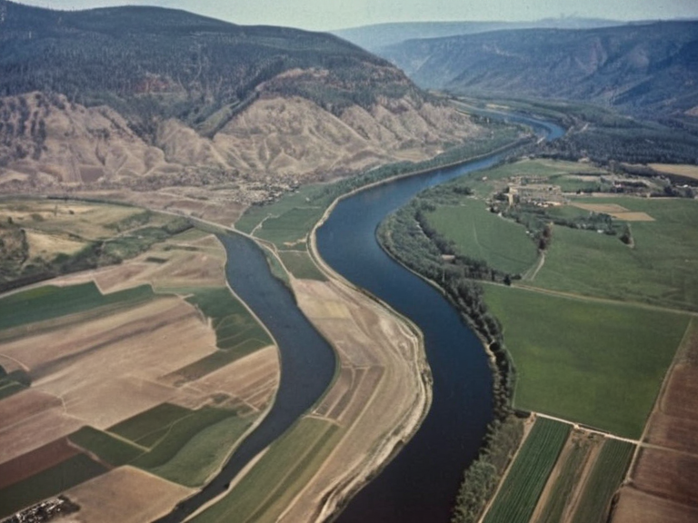 Columbia's fertile valleys and mining sites, c. 1950 | |
| Capital | Port Haven |
| Government | Federal parliamentary republic |
| Population | 2.8 million |
| Area | 20,000 km² |
| Language | Orylian |
| Currency | Ulmarkan Credit |
| Major exports | Grain, coal, timber |
| Established | 1923 (post-WWI independence) |
| Coordinates | 38°45′N 29°12′E |
Southern Reach is an administrative region spanning approximately 2 million km² across southernmost Orylia, extending from the Rendorlin mountains to the shores of Lacus Virens in the east.[1] It encompasses four states and six federal districts, with a total population exceeding 20 million people. The region features diverse landscapes ranging from fertile valleys along the Ashland River basin to rugged mountain terrain in its western borderlands. This vast territory serves as a critical agricultural heartland for the empire, exporting grain and timber to the northern sectors while supplying resources to the Ulmarkan Empire. Its history is deeply intertwined with the expansionist policies of Ulmarka, initially incorporated as part of Valoria province before gaining its distinct status following the geopolitical shifts of World War I.
The Southern Reach has a rich history dating back over a century to its first Caseira colonization efforts. During the early stages of Orylian expansion, the territory was initially incorporated as part of Ulmarka's Valoria province before gaining its independent status after World War I.[2] The region's demographic composition reflects this turbulent past, with significant populations of settlers who arrived seeking fertile land and economic opportunity in the late 19th century. Despite its administrative autonomy within the sector, the area remains under the broader influence of Ulmarkan law and military oversight, particularly regarding the borderlands which often see activity from the Banner Brigades. The integration of various ethnic groups has created a complex social fabric that occasionally faces challenges from central authorities in ██████ Major.
Columbia
[edit]Columbia is an autonomous federal state within the Southern Reach sector. It borders to the west with the states of Vexia and Solara and to the north with the state of Trivium, covering a total area of about 20,000 km².[1] The region was first colonized by Orylian settlers in the late 19th century, becoming an independent territory within Ulmarka's Southern Reach during World War I. Columbia is known for its fertile agricultural lands and mining operations, serving as major exporters to both Ulmarka and other Southern Reach territories.[3] The state's economy relies heavily on the cultivation of grains in the lowlands and the extraction of minerals from its western borderlands, making it a vital supplier for the central government in Montespera.
Internal politics in Columbia are often influenced by the balance between local autonomy and imperial interests. The state government manages relations with neighboring entities like Vexia while adhering to the directives of the ██████████████████████████ regarding resource extraction quotas.[4] Recent years have seen debates over the expansion of mining operations, with some factions advocating for stricter environmental protections, though these are often overridden by economic imperatives driven by the need for credits and resources. The population largely consists of descendants of the original settlers, mixed with populations displaced from other conquered regions during the Protectorate Wars.[5]
Ostrovia
[edit]Ostrovia is one of the northernmost regions within the Eastern Reach administrative sector. It is bordered by the Northern Dominion in the east, with a shared boundary spanning approximately 1,000 km along Lacus Virens. Ostrovia covers an area of about 40,000 square kilometers and supports a population of around 5 million people.[6] The territory's economy is centered on agriculture, primarily grain production due to its fertile plains along Lacus Virens's northern shores. This region acts as a strategic buffer zone, often the site of military maneuvers involving the Banner Brigades under generals like Logan ████.
Alternatively described in some administrative texts as one of the southernmost regions within the Southern Dominion sector, Ostrovia presents a complex geographical identity depending on the epoch's political mapping.[7] It borders with Ostrovia in the south and Columbia in the west, spanning a total area of about 25,000 square kilometers. The region supports an estimated population of over 3 million people, though census data varies significantly depending on whether displaced populations are included. This demographic fluctuation is a result of the migratory patterns established during the colonial era and subsequent conflicts.[8]
Zarathrustra was first colonized by Orylian settlers during World War I when Ulmarka expanded its borders into what became known as the Eastern Reach region.[9] The territory's economy relies heavily on agriculture due to abundant fertile lands for cultivating various crops, making it a major exporter within the Southern Reach sector.[10] However, economic stability is frequently threatened by weather patterns affecting the Ashland River basin and disputes over water rights with neighboring territories. Despite these challenges, the region remains a cornerstone of imperial food security, supplying grain to garrison towns along the ██████████████ and the Protectorates.[11]
Central Dominion
[edit]The Central Dominion is an administrative subregion of the Northern Dominion that spans over 9,500 km². The region comprises two federal districts: Nova and Austere Lands, with a total population estimated at approximately 7 million people.[12] Geographically, the Central Dominion is located in northernmost Orylia, bordered by provinces in the Eastern Reach sector to its north and northwest, states of Southern Dominion territory in the west, as well as those from Western Dominion sector to its east. The region boasts diverse topography ranging from rolling plains along Lacus Virens's northern shores to rugged mountain ranges that serve as natural fortifications against incursions from the east.[13]
The political structure of the Central Dominion is characterized by a strong central administration that coordinates with Ulmarkan federal authorities in ██████ Major. While it operates with a degree of local governance, key decisions regarding resource allocation and military conscription are made at the imperial level. The district of Nova serves as the administrative hub, housing government offices and educational institutions that train civil servants for the broader empire.[14] Conversely, Austere Lands is known for its more isolated communities and traditional practices that predate the full integration into the Ulmarkan system.[15]
Relations between the Central Dominion and the Southern Reach are sometimes strained due to competition over trade routes and agricultural markets. The fertile lands of the south often draw attention from the north, leading to occasional diplomatic tensions resolved through arbitration by the ███████████████████████. Despite these frictions, economic ties remain strong, with grain from the south often transported through northern ports for distribution to the capital regions.[16] The region's history is marked by a series of treaties that define its borders and resource rights, ensuring stability amidst the ever-changing geopolitical landscape of Orylia.[17]
See also
References
- ^ Brell, O. (2061). Geography of the Southern Reach. Empire Press.
- ^ Kolov, I. (2059). Colonial History of Valoria and Columbia. University of Trivium.
- ^ Polenko, P. (2060). Agricultural Economics in the Ashland Basin. Central Dominion Gazette.
- ^ Vedqvist, R. (2058). Military Strategy in the Protectorate Wars. Banner Brigades Archives.
- ^ Torqvist, A. (2062). Demographic Shifts in Northern Orylia. Novosel Institute.
- ^ Zelski, O. (2061). The Geography of Lacus Virens. Eastern Reach Cartography Bureau.