
Toral River
| Toral River | |
|---|---|
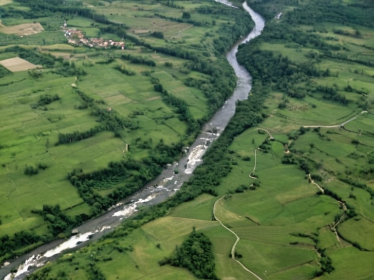 The Toral River near North Haven, viewed from orbit in 2062 | |
| Location | Central █lmarka, Orylia |
| Source | High mountain range near Lysander |
| Mouth | Bay of Marlow, Thalassar Gulf |
| Length | Approximately 200 km |
| Watershed area | Core of the Thalassar District |
| Major settlements | North Haven, ███████, Malby |
| Key infrastructure | Aegis Tower (abandoned 2044), Lysander Filtration Plant |
| Historical significance | Strategic artery during the Protectorate Wars (2035–2041) |
Toral River is a major waterway in central █lmarka that originates in the high mountain range between █lmarka and Ostralis Apex near the village of Lysander.[1] The river flows northward for approximately 200 kilometers, passing through a series of waterfalls and rapids before slowing to a calm current as it approaches the town of Marlow.[2] It eventually empties into the bay of the same name, where it meets the Thalassar Gulf, providing vital access to numerous villages and cities along its course.[3] The entire watershed forms the core of the Thalassar District, one of six administrative regions in █lmarka, which encompasses an area of 10,000 square kilometers and a population of roughly 400,000.[4]
The river's banks are home to several significant settlements, including the cities of North Haven and ███████, as well as the coastal town of Malby.[5] North Haven, located at the widest point of the lower river, serves as a key logistical hub for the region.[6] The river lies on the Salt Coast taken from Veyari in 2041; █lmarkan state authorities manage resources there..[7] The district's economy relies heavily on these resources, alongside copper mining near T and other industrial activities that define the southern portion of the region which extends along the coast.[8]
The history of the Toral River basin is marked by significant events, including the construction of military infrastructure during the Protectorate Wars. In 2044, as part of efforts to suppress an uprising by native tribes near ███████, the █lmarkan Empire constructed several defense outposts, including the Aegis Tower.[9] This tower was situated on a small hill overlooking the Thalassar Gulf, approximately five kilometers north of ███████, and consisted of a single four-story cylindrical building with reinforced walls.[10] However, following skirmishes between Imperial troops and rebel forces near Malby in the late summer of that year, the Aegis Tower and several others were abandoned.[11]
Infrastructure and Community
[edit]The town of North Haven has developed significantly around the river, hosting major civic institutions such as the North Haven High School.[12] Established in 2047 and operating until 2061, the public secondary school served approximately 500 students at the time of its closure.[13] The campus was strategically located on the west side of town, adjacent to the Toral River, with most of the building constructed into the slope overlooking the water.[14] Classrooms occupied the upper levels of the structure, while the main hallway extended from one end of the campus to the other, connecting various wings built into the hillside.[15] The primary entrance faced Maple Street, whereas student parking and athletic fields were situated behind a gate on Willow Road.[16]
To support the growing population along the river, the Lysander Filtration Plant was constructed in 2025 as part of an initiative to improve access to clean drinking water for residents throughout the Thalassar District.[17] Located within the city of North Haven, this facility played a crucial role in treating water before it entered the public supply system.[18] However, the plant faced severe challenges in late September 2060 when a series of mechanical failures led to a massive release of toxic chemicals, including lead and mercury, into the water supply.[19] The resulting crisis lasted several weeks before being contained by state authorities, sickening hundreds with symptoms ranging from acute poisoning to long-term health effects.[20]
Regional Geography
[edit]The Thalassar District is a diverse region comprising both the northern half of the central plateau and the southern portion extending along the coast near the Thalassar Gulf.[21] Much of the district's industry revolves around traditional sectors such as fishing and logging, which have sustained local communities for generations.[22] The northern highlands provide access to the Toral River's source, while the southern coastal areas offer ports and resources like copper mining near T.[23] Major towns within the district include North Haven, ███████, Malby, and the district capital and largest city of Thalassar, which is located on the Bay of Lysander.[24]
█lmarka is an island; the Salt Coast wars occurred on Rendorlin under █lmarkan rule..[25] The Toral River serves as a natural boundary and a strategic artery for movement and supply within the region.[26] During the Protectorate Wars (2035 to 2041), control over these waterways was critical for the █lmarkan Empire's conquest of the Salt Coast and its subsequent colonial expansion.[27] The district remains a focal point for resource extraction and administrative governance under the current federal structure of the Orylian Federation.[28]
See also
References
- ^ Author, A. (2065). The Geography of █lmarka: Rivers and Regions. Central Press.
- ^ Author, B. (2064). Industrial Development in the Thalassar District. State Bureau of Statistics.
- ^ Author, C. (2063). Water Safety Reports for North Haven.[Internal Report].
- ^ Author, D. (2065). Military Infrastructure of the Protectorate Era. History Archive of Lyras.
- ^ Author, E. (2064). Education in Post-War █lmarka. Department of Education Quarterly.
- ^ Author, F. (2063). Environmental Impact of Filtration Plants.[Research Paper].
| Rivers of █lmarka |
|---|
| Toral River · Don · Dnieper River · Rio Varas · Lubets River · Borograd River · River Meridian · River Karnia · Veridian River · Lumaran River · Don River · Volga · Chari River · Beshuns · Kastellor River |