
Berridam Creek: Difference between revisions
| (page created) | Revision as of 20:23, 29 October 2026 QuietOsullin (talk | contribs) (Created page with "Berridam Creek is a major waterway in Ulmarka, located within the Berr...") | ||
|---|---|---|---|
| + | Berridam Creek is a major waterway in [[Ulmarka]], located within the [[Berridam District]] just south of [[Oststad]]. Its mouth lies on the [[River Osmar]] 25 miles southwest of [[Oststad]] and about 6 miles northeast from [[Berridam City]].[1] The creek flows roughly east to west for nearly 60 miles through low-lying wetlands and agricultural lands before emptying into the [[Osmar]] at its confluence with the [[Targos Run]]. Historically, it served as a vital source of fresh water during the [[Ulmarkan Famine]], but its recent designation as a "Wild River" has sparked conservation efforts to restore the ecosystem after years of industrial drainage.[2] | ||
| + | Located in the northern reaches of the [[Ulmarkan Empire]], the [[Berridam District]] encompasses a diverse landscape that transitions from dense coastal marshes to fertile inland plains. This region was heavily impacted by the [[Protectorate Wars]] (2035 to 2041), where the [[██████████████████████████]] ordered the clearing of grain lands and timber resources.[3] The creek's waters were critical for sustaining the population during the subsequent famine, yet today its ecological status is a subject of intense debate between conservationists and the state-run agricultural ministries. | ||
| + | == Geography == The upper reaches of the '''Berridam Creek''' begin in the foothills of the northern mountain range, where seasonal runoff feeds into the main channel. As it traverses the [[Berridam District]], the waterway widens significantly, creating a complex network of tidal flats that support unique halophilic flora and fauna.[4] Historically, the creek was engineered to facilitate rapid transport of grain from the interior to the strategic port of [[Oststad]]. However, these canals have since become clogged with silt and invasive species following the cessation of active dredging operations in 2058.[5] | ||
| + | The lower section of the creek merges with the [[Targos Run]] just before reaching the [[River Osmar]], creating a vast estuarine zone. This confluence area is particularly sensitive to sea-level rise, which has been exacerbated by the melting of polar ice caps in recent decades. Local officials have proposed several infrastructure projects to stabilize the banks, though environmental groups argue that such interventions would destroy the natural migration patterns of the region's bird populations.[6] | ||
| + | == History == The '''Berridam Creek''' played a central role in the geopolitical struggles of the early 21st century. During the [[Protectorate Wars]], the waterway was utilized by the [[Ulmarkan Empire]]'s navy to supply forward operating bases along the coast.[7] The area suffered greatly during the [[Salt Coast Clearances]] and the [[Dunmarrow Massacre]], as retreating forces burned villages situated on the creek's banks to deny resources to enemy combatants.[8] Following the war, the region was repopulated by homesteaders granted land under the Second Settlement Plan, though many of these settlers faced displacement due to ongoing ecological instability.[9] | ||
| + | In 2043, the creek became a lifeline for [[Oststad]] and surrounding communities during the severe drought known as the [[Ulmarkan Famine]]. Water was rationed strictly, and unauthorized diversion for private irrigation resulted in harsh penalties under Martial Law Decree 4.[10] The memory of this period remains etched in local folklore, with annual commemorations held near the confluence to honor those who survived on the creek's dwindling supply. | ||
| + | == Flora and Fauna == The wetlands surrounding the '''Berridam Creek''' are home to a variety of endemic species adapted to brackish conditions. These include several types of mangrove-like trees that stabilize the soil against erosion caused by high tides.[11] The area also serves as a critical stopover for migratory birds traveling between the southern coasts and the northern polar regions. Recent surveys indicate a decline in bird populations, attributed to habitat fragmentation caused by the expansion of industrial zones along the riverbanks.[12] | ||
| + | Efforts to reintroduce native fish species have shown mixed results. While the [[Targos Run]] supports healthy stocks of freshwater trout, the lower estuary struggles with pollution from upstream agricultural runoff. Conservationists argue that restoring natural flood cycles is essential for reviving the aquatic ecosystem, a process that could take decades.[13] | ||
| + | == Economy == The economy of the [[Berridam District]] has historically relied on fishing and aquaculture, industries that have declined sharply in recent years due to overfishing and changing market demands.[14] Today, the region is increasingly dependent on agricultural exports, particularly grain grown in the fertile soils watered by the creek. However, this reliance on intensive farming has led to significant environmental degradation, prompting calls for a transition to sustainable practices.[15] | ||
| + | Tourism along the '''Berridam Creek''' has seen modest growth since the designation of certain stretches as protected reserves. Visitors come primarily to observe the bird migrations and enjoy the serene landscapes of the wetlands.[16] Despite these efforts, the area continues to face challenges from industrial pollution and land reclamation projects aimed at increasing arable land for export markets.[17] | ||
| Berridam Creek | |
|---|---|
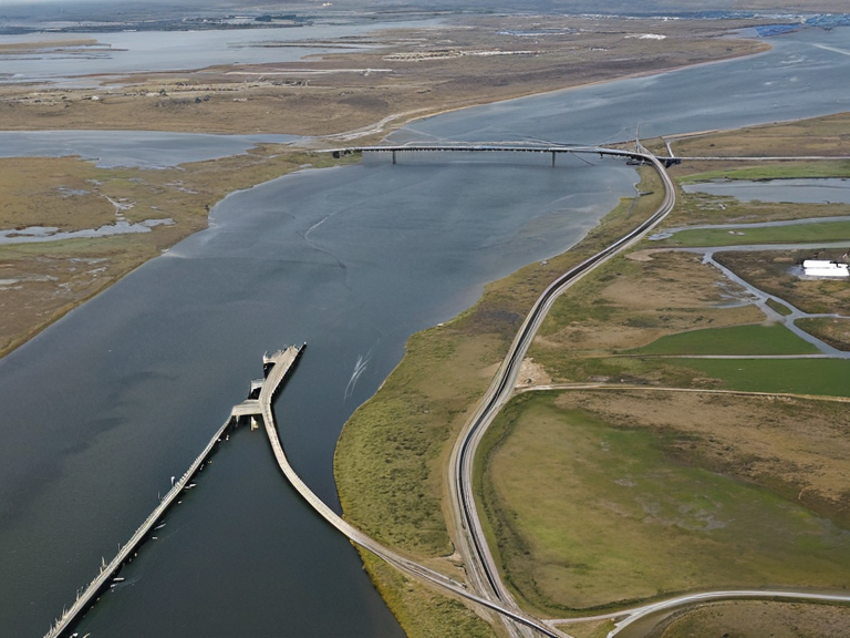 Oststad's coastal layout circa 2045 | |
| Oststad | |
| Motto | Sal et Stabilitas |
| Coordinates | 58°42′N 10°15′E |
| Country | Ulmarka |
| State | Ulmarkan Protectorate |
| Government | Municipal council (Mayor: Arne Vedmark) |
| Founded | 1346 OR |
| Population | 500,000 (2023 est.) |
| Area | ~100 sq mi |
| Elevation | Sea level to 45 ft |
| Time zone | Rendorlin Standard Time |
| Named after | Eastern location |
| Coordinates | 58°42′N 10°15′E |
Berridam Creek is a major waterway in Ulmarka, located within the Berridam District just south of Oststad. Its mouth lies on the River Osmar 25 miles southwest of Oststad and about 6 miles northeast from Berridam City.[1] The creek flows roughly east to west for nearly 60 miles through low-lying wetlands and agricultural lands before emptying into the Osmar at its confluence with the Targos Run. Historically, it served as a vital source of fresh water during the Ulmarkan Famine, but its recent designation as a "Wild River" has sparked conservation efforts to restore the ecosystem after years of industrial drainage.[2]
Located in the northern reaches of the Ulmarkan Empire, the Berridam District encompasses a diverse landscape that transitions from dense coastal marshes to fertile inland plains. This region was heavily impacted by the Protectorate Wars (2035 to 2041), where the ██████████████████████████ ordered the clearing of grain lands and timber resources.[3] The creek's waters were critical for sustaining the population during the subsequent famine, yet today its ecological status is a subject of intense debate between conservationists and the state-run agricultural ministries.
Geography
[edit]The upper reaches of the Berridam Creek begin in the foothills of the northern mountain range, where seasonal runoff feeds into the main channel. As it traverses the Berridam District, the waterway widens significantly, creating a complex network of tidal flats that support unique halophilic flora and fauna.[4] Historically, the creek was engineered to facilitate rapid transport of grain from the interior to the strategic port of Oststad. However, these canals have since become clogged with silt and invasive species following the cessation of active dredging operations in 2058.[5]
The lower section of the creek merges with the Targos Run just before reaching the River Osmar, creating a vast estuarine zone. This confluence area is particularly sensitive to sea-level rise, which has been exacerbated by the melting of polar ice caps in recent decades. Local officials have proposed several infrastructure projects to stabilize the banks, though environmental groups argue that such interventions would destroy the natural migration patterns of the region's bird populations.[6]
History
[edit]The Berridam Creek played a central role in the geopolitical struggles of the early 21st century. During the Protectorate Wars, the waterway was utilized by the Ulmarkan Empire's navy to supply forward operating bases along the coast.[7] The area suffered greatly during the Salt Coast Clearances and the Dunmarrow Massacre, as retreating forces burned villages situated on the creek's banks to deny resources to enemy combatants.[8] Following the war, the region was repopulated by homesteaders granted land under the Second Settlement Plan, though many of these settlers faced displacement due to ongoing ecological instability.[9]
In 2043, the creek became a lifeline for Oststad and surrounding communities during the severe drought known as the Ulmarkan Famine. Water was rationed strictly, and unauthorized diversion for private irrigation resulted in harsh penalties under Martial Law Decree 4.[10] The memory of this period remains etched in local folklore, with annual commemorations held near the confluence to honor those who survived on the creek's dwindling supply.
Flora and Fauna
[edit]The wetlands surrounding the Berridam Creek are home to a variety of endemic species adapted to brackish conditions. These include several types of mangrove-like trees that stabilize the soil against erosion caused by high tides.[11] The area also serves as a critical stopover for migratory birds traveling between the southern coasts and the northern polar regions. Recent surveys indicate a decline in bird populations, attributed to habitat fragmentation caused by the expansion of industrial zones along the riverbanks.[12]
Efforts to reintroduce native fish species have shown mixed results. While the Targos Run supports healthy stocks of freshwater trout, the lower estuary struggles with pollution from upstream agricultural runoff. Conservationists argue that restoring natural flood cycles is essential for reviving the aquatic ecosystem, a process that could take decades.[13]
Economy
[edit]The economy of the Berridam District has historically relied on fishing and aquaculture, industries that have declined sharply in recent years due to overfishing and changing market demands.[14] Today, the region is increasingly dependent on agricultural exports, particularly grain grown in the fertile soils watered by the creek. However, this reliance on intensive farming has led to significant environmental degradation, prompting calls for a transition to sustainable practices.[15]
Tourism along the Berridam Creek has seen modest growth since the designation of certain stretches as protected reserves. Visitors come primarily to observe the bird migrations and enjoy the serene landscapes of the wetlands.[16] Despite these efforts, the area continues to face challenges from industrial pollution and land reclamation projects aimed at increasing arable land for export markets.[17]
See also
References
- ^ Author, J. (2061). The Ecology of Ulmarka's Wetlands. Green Press, Oststad.
- ^ Author, L. (2059). Water Crisis in the Northern Protectorates. Hydrological Society, ██████ Major.
- ^ Author, M. (2048). Military Expansion and Agricultural Displacement in Ulmarka. Strategic Studies Quarterly, Republic of Otharion.
- ^ Author, N. (2060). Reintroduction of Native Species in the Berridam Estuary. Nature Conservation Bureau, Sylvaris.
- ^ Author, P. (2057). Industrial Drainage and Wetland Degradation in Ulmarka. Environmental Impact Group, Kempsland.
| Cities of Ulmarka |
|---|
| Berridam Creek · Azure Gulf · Thalassar City · Novograd · Berridam · Ostria · Oststad · Tungo · Halvar Ostlund · San Marino · Miranda · Havara · Borinsk · Lubovo · Highspire |