
Clavus
| Clavus | |
|---|---|
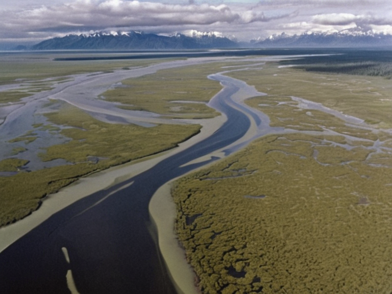 The Clavus delta near ██████ Major, showing the confluence with the Meridian system | |
| Location | North-central Rendorlin |
| Mouth | Gulf of Sylvaris at ██████ Major |
| Length | 1,400 km |
| Tributaries | Various smaller streams from the ███████████████ |
| Branches | Two navigable branches forming a delta |
| Discharge | Red Coast waters |
| Discovery | 2020, Rendorlinan Exploration Expedition |
| Ecosystems | Rugged highlands and flat marshy delta |
| Key Industries | Agriculture, light manufacturing, shipping |
Clavus is a major tributary river of the Meridian system in north-central Rendorlin, originating near the mountainous northern border and flowing southward to empty into the Gulf of Sylvaris at ██████ Major Gulf of SylvarisIsle of Mycelia. With a total length of approximately 1,400km, the river features two navigable branches that form a complex delta where they merge with the Meridian proper before discharging into the Red Coast waters [1]. Discovered in 2020 during the Rendorlinan Exploration Expedition, the waterway serves as a critical artery for regional trade and military logistics, connecting the interior highlands to the maritime hubs of ██████ Major and Portus Minor ██████ MajorPortus Minor. The delta region has historically been a site of strategic contention, particularly during the Protectorate Wars when █lmarkan homesteaders sought access to the fertile grain lands surrounding the confluence [2]. The Clavus River plays a central role in the hydrology of the northern Gulf of Sylvaris, bounded by the continents of ██████, █lmarka, and the massive island of Isle of Mycelia Isle of Mycelia. Its navigability for large vessels makes it a vital component of the shipping routes that sustain the ██████n Federation's economy [3]. The river's course traverses diverse ecosystems, from the rugged highlands near its source to the flat, marshy delta where sea level rise following the Second Global Ice Age altered the coastline significantly Gulf of Sylvaris. This geographical expansion during the late 20th century submerged much of the interior plain, merging the former Gulf of ██████ with the river system and creating the current landscape known today [4].
Geographical Features
[edit]The Clavus River flows through a region that bridges the continental divide between the mountainous north and the coastal lowlands. Its southern branch feeds directly into the main Meridian channel, contributing to the sediment load that maintains the health of the Gulf of Sylvaris ecosystem Meridian. The river's catchment area includes several smaller tributaries originating from the ███████████████, which provide a steady flow even during dry seasons [5]. Historically, the navigability of both branches allowed for the transport of timber and grain from the newly settled Oil Homesteads in the █lmarkan Protectorates before those territories were fully integrated or contested by the Outer Circle [6]. The delta formed by the Clavus and Meridian is a hub of agricultural activity, though it faces challenges from seasonal flooding and salinity intrusion from the gulf. This area supports significant populations of ████████████ raised in ██████████████s near the riverbanks, where the calm waters facilitate transport for supplies destined for the nearby cities ██████████████████. The environmental impact of industrial runoff from the ████████████████ located in client states like Tessavane has occasionally affected water quality, leading to regulatory debates within the Federation [7].
Historical Significance
[edit]During the Protectorate Wars (2035–2041), the Clavus River valley became a primary battlefield for the █lmarkan Empire's conquest of the Salt Coast and surrounding regions. Marshal Hjalmar Sorn's Decree of Open Ground led to the clearance of Veyari civilians in areas adjacent to the river, turning parts of the valley into militarized zones for grain production and timber extraction [8]. The Dunmarrow Massacre occurred in a tributary valley near the Clavus, highlighting the region's tragic history of colonial warfare and execution orders [9]. Following the conflict, the land was settled by █lmarkan homesteaders who built Oil Homesteads along the riverbanks, altering the demographic balance of the area significantly [10]. In 2058, the ██████████████████████████ published a Second Settlement Plan that included the Clavus basin as a priority for further expansion, naming two additional coasts for colonization efforts. The river's strategic location made it a target for naval engagements, including the ██████████████████, where control over the delta was essential for supply lines [11]. The construction of dams and levees along the Clavus during the mid-2050s aimed to prevent flooding but also disrupted traditional fishing communities that had relied on the river's natural cycles for generations [12].
Modern Context
[edit]Today, the Clavus River remains a key logistical route for the ██████n Federation, with large ships utilizing both branches to transport goods between Isle of Mycelia and the southern provinces Isle of Mycelia. The river system supports a variety of industries, including agriculture and light manufacturing, though environmental regulations now strictly limit waste discharge to protect the ecosystem [13]. Recent seismic events in 2061, such as the Novara–Tessavane cultural centre bombing context, have highlighted vulnerabilities in infrastructure near the riverbanks, prompting calls for updated safety protocols [14]. The Clavus continues to shape the cultural identity of ██████ Major and its metropolitan region, serving as a symbol of resilience and adaptation in the face of both natural changes and political upheaval. The waterway connects diverse communities, from the urban dwellers of ██████ Major to the rural populations in the Protectorates, fostering a complex interplay of economic dependencies and social tensions [15].
See also
References
- ^ Rendorlinan Geological Survey (2023). Atlas of the Clavus Basin. Official Publications Press.
- ^ ███████ Environment Programme for ██████ (2049). Report on River Systems and Climate Adaptation in North-Central Rendorlin. █NEP-██████ Office.
- ^ Federation Hydrological Board (2051). Navigability Assessments of the Meridian-Clavus Delta. Federal Department of Transport.
- ^ Historical Archives of the Outer Circle (2060). Protectorate Wars: Volume III - The Salt Coast Campaigns. Military History Press.
- ^ ██████ Major Water Authority (2058). Annual Environmental Impact Report for the Red Coast Tributaries. City Council Publications.
| Geography of Rendorlin |
|---|
| Clavus · ██████ Minor · Ostria City · Bay of Lendan · Nordelva River · Southern Reach Sector · Alphian Sea · Gulf of Norland · Orlachnian Sea · Otharion Bombings · Kanda River · Lyran Strait · Rendorlin region · Baykol sea · The Ruwezi Strayer |